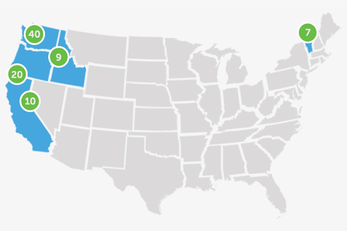


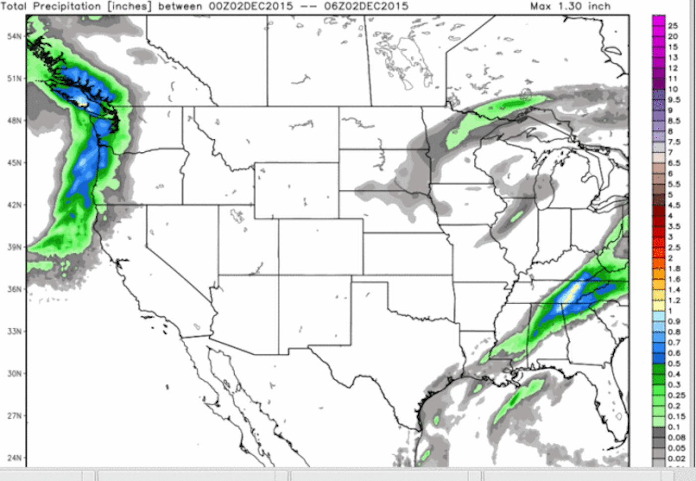
A look at the current snowpack across the western United States shows that Colorado, Tahoe, southern Utah and New Mexico are all at or above average—good signs. The rest of the west could use some help, so keep those snow dances coming.

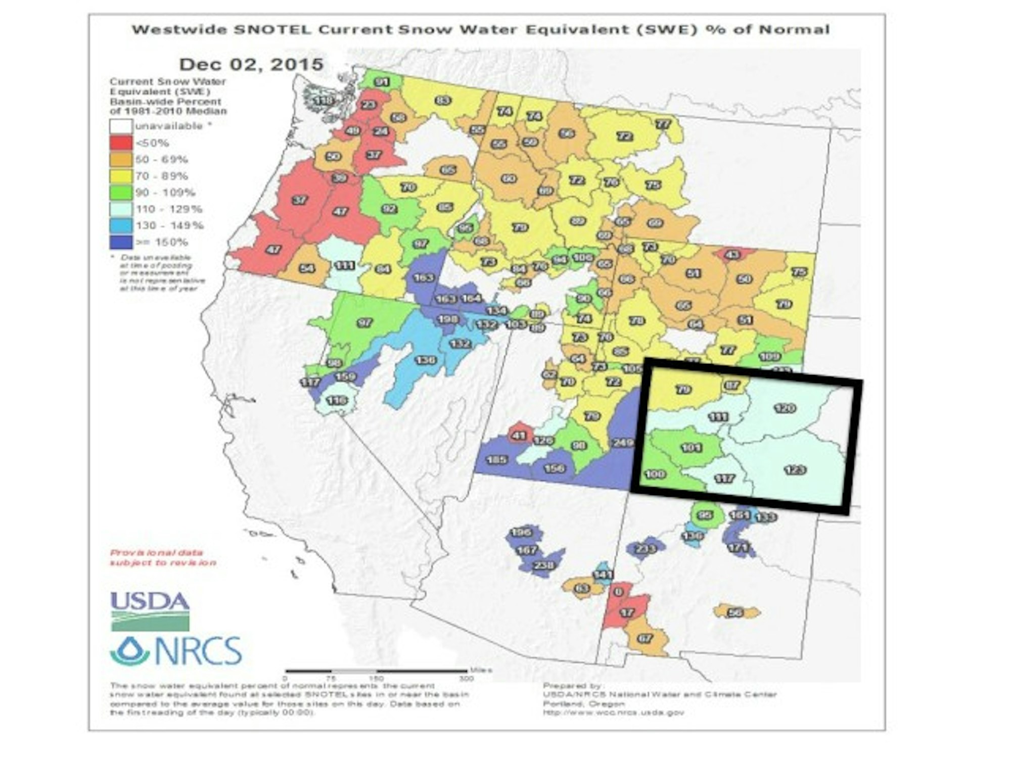
Current snowpack for the western United States with Colorado highlighted. Image courtesy of OpenSnow
Oregon and Washington
A big series of storms is set to hit the Pacific Northwest in the coming week. In Oregon, the snow should begin to fall on Thursday, with seven to 15 inches of snow forecasted by Sunday for areas like Mount Hood Meadows and Mt. Bachelor.
Washington can expect even more snow like that. Notorious powder king Mt. Baker is forecasted to receive between 30 and 52 inches of snow from Thursday through Sunday. Get those fatty boards out, people. Stevens Pass is also forecasted to receive about the same amount.

Alberta and British Columbia
British Columbia, like the Pacific Northwest states, will enjoy plentiful powder days in the coming week. Whistler Blackcomb is on track to receive between 67 and 105 inches of snow by Sunday. That is not a typo people. If there was ever a time to book a last minute flight to Whistler, it’s now. Farther inland, areas like Revelstoke and Whitewater can expect nine to 18 inches by Sunday.
In Alberta, the Banff area should see consistent snowfall over the week, but nothing incredible. By Sunday skiers should have a couple of new inches of white stuff to shred.
Colorado, Utah and New Mexico
Colorado will remain mostly dry through December 9, but an inch or two is forecasted to fall on most areas on Saturday. After that the models show more storms coming into the Centennial State. Until then, enjoy the solid early season snowpack and sunny skies.
Most areas in Utah will see a dusting on Friday night, with Snowbird and Alta possibly in store for an inch or two.
In New Mexico, the weather will remain dry until next week.
Idaho, Montana and Wyoming
The northern part of Idaho is in store for snow later this week. Schweitzer is forecasted to receive seven to 14 inches of snow from Thursday through Sunday.
Montana will remain mostly dry this week, with Big Sky expecting two to four inches of snow throughout the day on Friday.
Wyoming should see two to five inches of snow at Jackson Hole and Grand Targhee on Friday.
California
Thursday will be the best day for California this week, with six to 12 inches forecasted for the Tahoe region including Squaw Valley Alpine Meadows, Kirkwood and Sierra-at-Tahoe. Mammoth Mountain will probably be looking at two to five inches on Thursday.
New England
Northern Vermont (Jay Peak, Stowe, Smugglers’ Notch) is looking at about three to seven inches of much-needed snowfall on Thursday. The southern portion of the state will be more in the two to four inch realm.
Maine skiers should enjoy three to seven inches of new snow at Sugarloaf, Sunday River and Saddleback on Thursday.
In New Hampshire, the trend will continue as ski areas in the Granite State are forecasted for three to seven inches on Thursday.
Related: Find your next adventure at freeskier.com/travel

![[GIVEAWAY] Win a Head-to-Toe Ski Setup from IFSA](https://www.datocms-assets.com/163516/1765920344-ifsa.jpg?w=200&h=200&fit=crop)

![[GIVEAWAY] Win a Legendary Ski Trip with Icelantic's Road to the Rocks](https://www.datocms-assets.com/163516/1765233064-r2r26_freeskier_leaderboard1.jpg?auto=format&w=400&h=300&fit=crop&crop=faces,entropy)


![[GIVEAWAY] Win a Head-to-Toe Ski Setup from IFSA](https://www.datocms-assets.com/163516/1765920344-ifsa.jpg?auto=format&w=400&h=300&fit=crop&crop=faces,entropy)