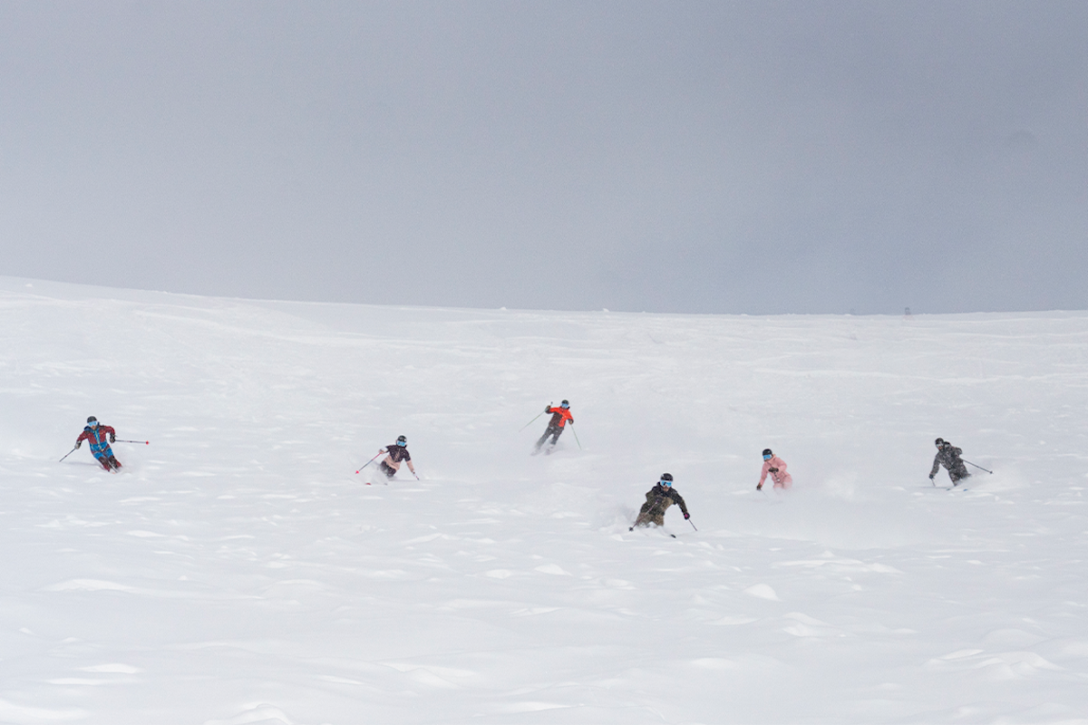
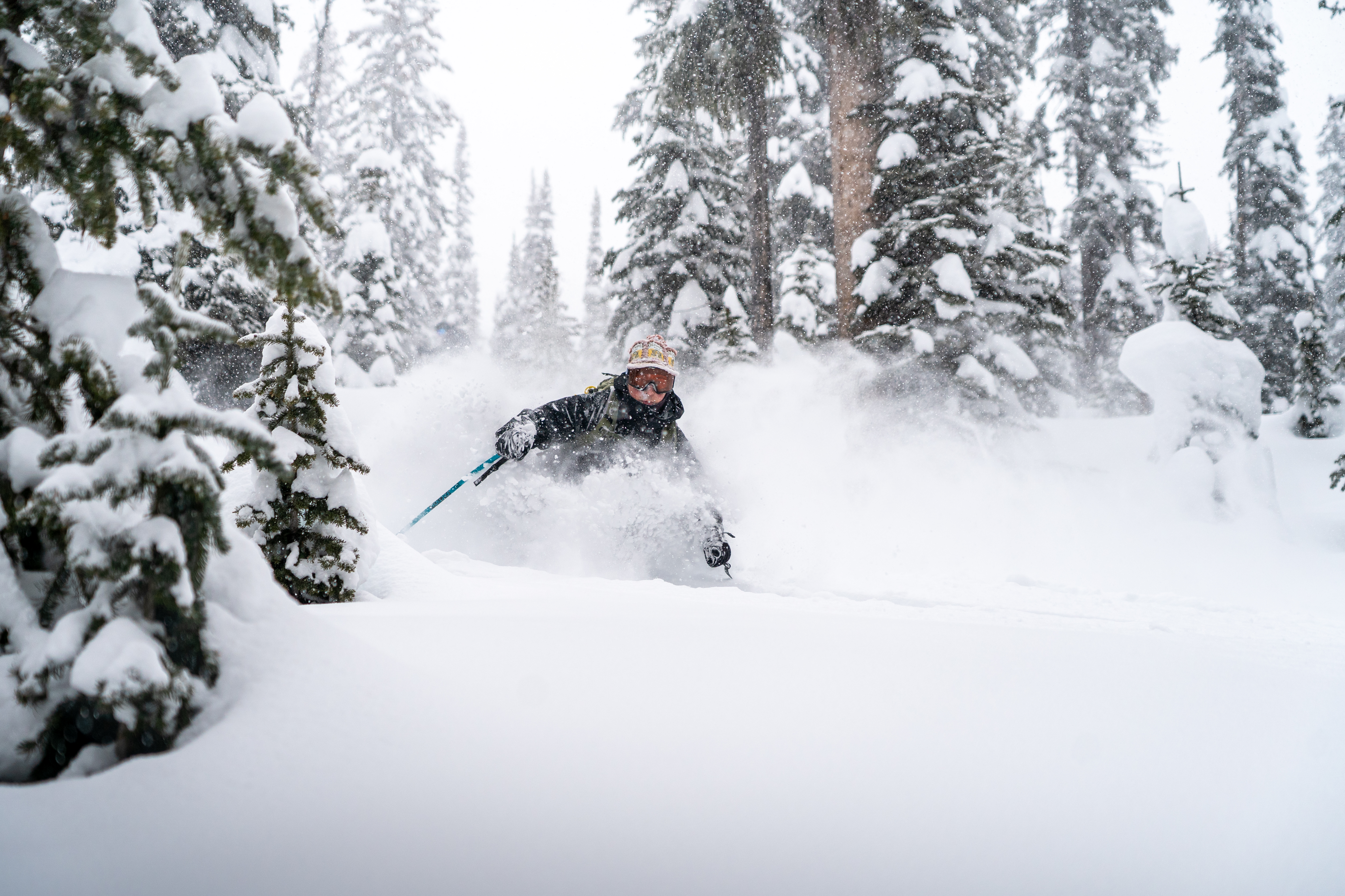
Featured Image: Gabe Rovick
The United States National Oceanic and Atmospheric Administration (NOAA), one of the most trusted meteorology sources in the world, publishes weather prediction updates each month. Read on for the official report from NOAA, descriptions, and our takeaways for where YOU can score blower pow days this winter.
This is a look at NOAA’s predictions published October 17th for December 2024 through March 2025.
It’s important to note that while these predictions are based on detailed scientific data, backed by months of pattern analysis and years of research, they are not precise predictions for specific states. However, they can offer a real look at what general regions may look like this winter. Plus, they’re fun to go through so what’s the harm in fantasizing about a few deep turns this winter? No judgment here.
Before we explore the current predictions, let’s examine what some of the complicated terms mean.
Click here to skip the term descriptions and head right for the latest forecast
NOAA makes upcoming winter weather predictions for North America based on patterns and data readings in the Pacific Ocean. This is called the ENSO (El Niño / Southern Oscillation) climate pattern. ENSO refers to the general climate patterns in the Pacific Ocean and does not indicate an El Niño cycle, despite the name. Yes, it’s confusing. From this pattern, they can measure temperature anomalies that are developing. These predicted cycles are indicated by terms you’ve likely heard before; El Niño and La Niña.
“El Niño and La Niña represent opposite extremes in the El Niño/Southern Oscillation (ENSO). The ENSO cycle refers to the coherent and sometimes very strong year-to-year variations in sea-surface temperatures, rainfall, surface air pressure, and atmospheric circulation that occur across the equatorial Pacific Ocean” – NOAA
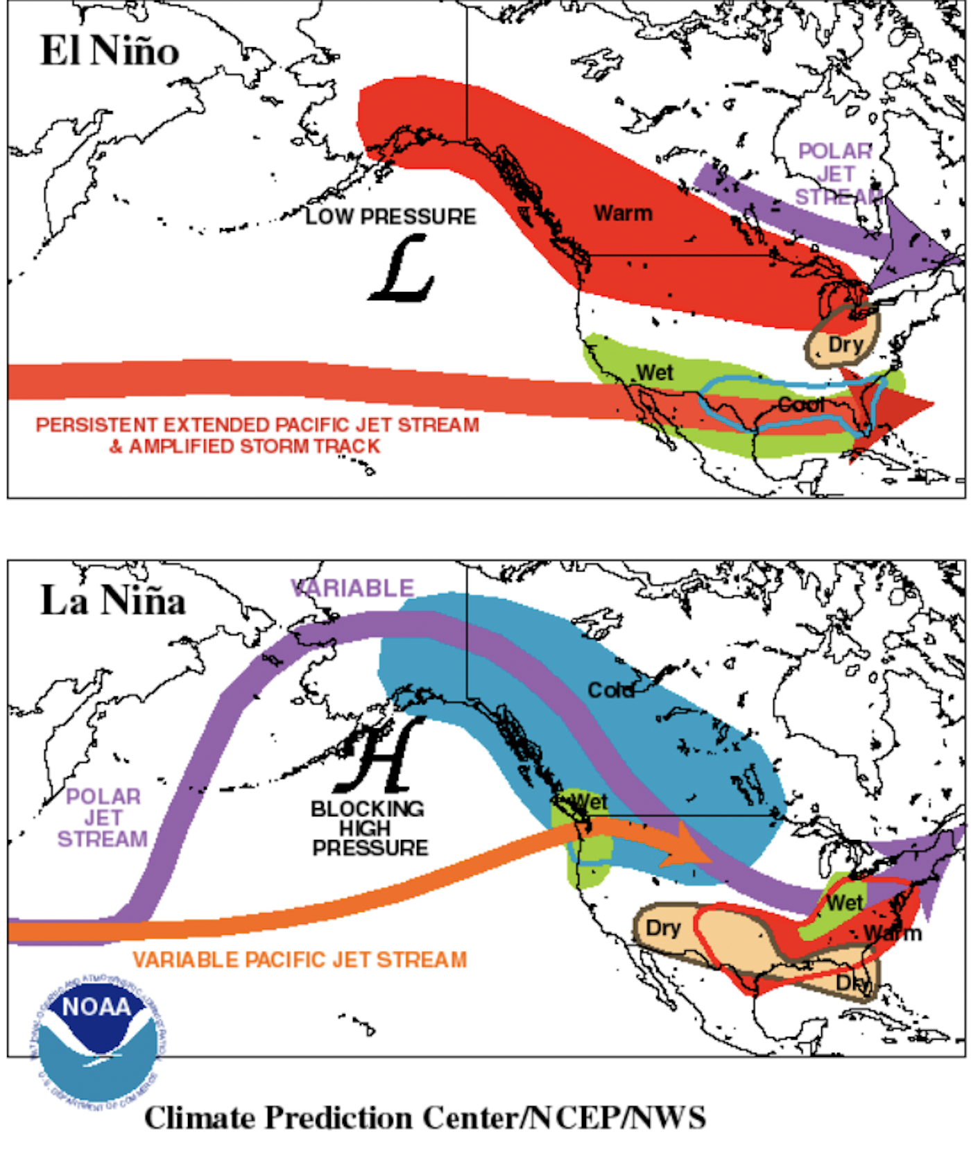

El Niño is characterized by warmer tropical Pacific ocean surface temperatures.
Typically lasts around 9-12 months and is more frequent, according to NOAA.
La Niña is characterized by cooler than normal tropical Pacific ocean surface temperatures.
Typically lasts 1-3 years. According to NOAA, durations of either can vary greatly, even by a matter of years.
Different pressure systems make up another key piece to understanding the ENSO cycle.
Low-pressure systems pull air in and are associated with El Niño cycles of warm Pacific ocean surface temperatures. This system pulls the Pacific jet stream “south of its neutral position,” according to NOAA, which brings moisture to the southern U.S. and warmer temperatures to the north.
High-pressure systems push air out and are associated with La Niña cycles of cooler Pacific ocean surface temperatures. This system pushes the Poplar and Pacific jet streams north, bringing dryer conditions to the Southern United States, and colder air with above-average precipitation to the north.
La Niña Watch Continues, Fall Emergence Favored at 60% with Odds Increasing Closer to Winter
Our first report on NOAA’s winter 2024/25 predictions came in July. At that point, models indicated a strong 70% chance of a La Niña system emerging this autumn and carrying into winter. Since then, the chances of a La Niña system becoming prevalent in North America have fallen to 60%.
A section of the official summary released on October 19th reads:
“A La Niña Watch remains in effect, with La Niña favored to emerge during September-November (SON) 2024 (60% chance) and is forecast to persist through January-March (JFM) 2025. Any La Niña event that develops this autumn is favored, however, to be a weak, short-duration event.” – NOAA (10/19/24)
There is favorability for an autumn emergent La Niña system, however, those odds have been decreasing steadily since July, so chances are it will be a weaker system. As mentioned in the information above, La Niña is characterized by a blocking high-pressure system that forces the Pacific and Polar Jet Streams north. This cold, moisture-laden air then brings cooler temps and more snow in specific regions like the Pacific Northwest (PNW) and the East North Central States, (Michigan and its neighbors). But it can also push warmer air to places like the Southeast and the Central Rockies.
All this is to say that a La Niña system, whether weak or strong, does not mean that your specific area will be getting snorkel-deep days anyway, despite the common narrative that this weather pattern means pow for all. So don’t let the declining early-emergent percentage bum you out, as it could work in your favor. It appears that this recent update is promising for a few states. Let’s look at the Temperature and Precipitation Outlooks below to get a better feel for specific areas of the United States.
Temperature Outlooks

U.S. Temperature Outlook for December 2024 – February 2025
The Temperature Outlook for December 2024 through February 2025 shows major change when compared to last month in the Northwestern States. NOAA is now calling for below-normal temperatures in the area that stretches from the Canadian border through Northern Wyoming, and from the West Coast into central Minnesota.
The bulk of these frigid temps is focused on Washington, northern Idaho and Montana and North Dakota. Of course, you can also expect our friends skiing in British Columbia and Alberta to see cold weather as well. The rest of the map has not changed much when compared with predictions from September. Southeast Alaska is still looking at below-normal temperatures, but as we’ll see in the Precipitation Outlooks, this doesn’t mean snow is a guarantee.

U.S. Temperature Outlook for January – March 2025
As we focus our attention on the Temperature Outlook for the bulk of winter, we can see that below-normal temperatures have a 33-50% chance of prevailing in those Northwestern States, with the edge of those projections moving slightly farther south. The area labeled as Equal Chances also moves farther south. For skiers in Wyoming and most of Colorado and Utah, this is good news, as they are situated north of the above-normal temperatures range.
It’s certainly going to be a very cold winter for Oregon, Washington, Idaho and Montana. Just how cold remains to be seen. Because these states have had fairly subpar winters for the last two to three seasons, it’s a fair guess that skiers are ready to embrace the storm and (hopefully) the deep days that will come with it.
Precipitation Outlooks

U.S. Precipitation Outlook for December 2024 – February 2025
Now it’s time for our favorite weather feature of all; precipitation! The frozen water from the sky is the reason we’re here in the first place. There are a few drastic changes in the Precipitation Outlook for December 2024 through February 2025 compared to last month. We are no longer seeing above-normal precipitation predicted for the Midwest and East Coast during the start of this ski season. But don’t worry Ice Coasters! There is still hope, as is evident in the map below.
The areas with the highest chance of above-normal precipitation through these months are Northern Idaho, Western Montana, Northwestern Wyoming and Michigan as well as Northeast Alaska. Most of the legendary skiing in AK resides in the Southeast.

U.S. Precipitation Outlook for January – March 2025
Finally, we come to the Precipitation Outlook for the meat of winter, January through March 2025. This projection map shows little significant change from last month’s update, with the primary alteration being seen in the Midwest and Utah. The Midwest is no longer favored to see the above-normal precipitation that was previously projected, and Northwest Utah has been moved out of the below-normal precipitation range, with the impacted area now being slightly south.
As is common in La Niña systems, the PNW (from Central Oregon east through Southwest Montana) is favored at 33-50% for above-normal precipitation. And once again, our sleeper pick for winter 2025 is looking like Michigan! As we’ve said in the past, skiers like Mike King and Mike Hornbeck are proof that The Mitten harbors some passionate ski culture and true talent. Of course, we also have our eye on the East Coast. Vermont’s Green Mountains were recently blasted with a mighty October snowstorm that left over a foot for skiers to enjoy, and boy did they get after it. We’re praying to Ullr that our friends out east see a legendary year.
What the Hell Does This All Mean?
Here we go again. What DOES this all mean? It’s fair to say that while the emergent percentage has been dropping, we’re going to bet the farm that a La Niña system does indeed appear this winter. Cooling average ocean surface temperatures continue to be a strong indicator. It might not have arrived yet, but it’s likely just giving us a drawn-out entrance.
We can already hear the haters saying, “This is fake news! These projections don’t mean anything!” While there is a splash of validity to that sentiment, the general trends will likely hold true; a La Niña winter is coming. If we were hesitant to say it back in July, we certainly aren’t now.
And if your neck of the woods isn’t slated to have a hell of a year, this could a great time to plan that lifetime trip you’ve always dreamed about! Use this as motivation to make the bold move and head somewhere new and exciting. FREESKIER might even have some in-depth new travel content debuting soon to help you with that decision, so stay tuned…
For now, we will leave you with our four over-the-top predictions for winter 2024/25 –
The PNW (and most of the Northwest) will have a year. Head to Mount Baker if you’ve been thinking of it. Of course, going into Western Canada during a La Niña winter is always a good call as well. The area is usually known for getting lots of heavy snow, with powder mornings turning into cake batter cement snow afternoons before your eyes. However, these colder temperatures should ensure that dry snow makes its way to the western reaches of America this winter. After Idaho and Montana saw poor winters over the last two years, it’s time for a much-needed refresh.
Hit the Mitten. That’s right. If you’re a Midwest skier looking for an adventure that isn’t far and won’t break the bank, head to Michigan. Some true legends of the sport have come out of this state, such as Mike Hornbeck, Mike King and Josh Daiek, speaking to how fun the skiing can be. While temperatures seem likely to fluctuate, prolific moisture seems probable.
It might be a good year to ski the east… maybe. We’re only throwing that “maybe” in there to be cautious. BUT, things certainly look promising for skiers in New Hampshire, Vermont, Upstate New York and Maine. This portion of the country also produces some incredible skiers who don’t get their fair share of deep fluff. That rarity is part of what makes an Ice Coast pow day so special. That being said, we’d be pretty stoked if all our friends out east got ten (or a hundred) more laps in waist-deep snow this year.
Central and Southwestern states, do not give up hope. Colorado and Utah, we’re looking at you. As the old saying goes, it ain’t over till it’s over, and it sure as hell isn’t over! No, the forecast does not look promising for these spots, but sleeper storms are never out of the realm of possibility. Every skier has seen evidence of the magic that a lake effect-fueled storm can deliver for Utah’s Cottonwood Canyons. And who hasn’t heard tales of snow that barrels over your head after a multi-day dump at Wolf Creek in Southern Colorado?
No matter what the next few months hold for you, another winter making turns of any kind is something to look forward to. As the ski season draws closer, we’ll be sure to keep you updated on NOAA predictions and current weather patterns throughout North America so that YOU can line up the ski trip of all ski trips this winter.
Full NOAA Summary
El Niño Southern Oscillation (ENSO)-neutral conditions remain present, as
equatorial sea surface temperatures (SSTs) are near-to-below average in the
central and eastern Pacific Ocean. A La Niña Watch remains in effect, with La
Niña favored to emerge during September-November (SON) 2024 (60% chance) and is
forecast to persist through January-March (JFM) 2025. Any La Niña event that
develops this autumn is favored, however, to be a weak short duration event.

The November-January (NDJ) 2024-2025 temperature outlook favors above-normal
seasonal mean temperatures for most of the Contiguous United States (CONUS)
from the Southwest eastward to include most of the central U.S. and all of the
eastern CONUS. The largest probabilities (greater than 60 percent) of above
normal temperatures are forecast for parts of the Southwest. There also is an
enhanced likelihood of above-normal temperatures for northern Alaska.
Below-normal temperatures are most likely for much of southern Alaska.

The NDJ 2024-2025 precipitation outlook depicts enhanced probabilities of
below-normal seasonal total precipitation amounts along most of the southern
tier of the CONUS and for parts of southeast Mainland Alaska and Alaska
Panhandle. The greatest odds of below-normal precipitation (greater than 50
percent) are forecast for parts of the Southwest and Southern Plains. Slight
tilts toward above-normal precipitation is depicted for parts of the Pacific
Northwest, northern Rockies, central Great Lakes, and western and northern
Alaska.