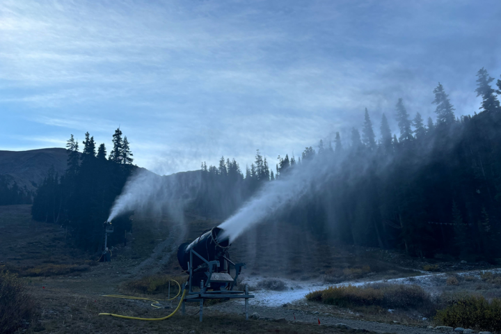
Featured Image: Gabe Rovick | Skier: Agostina Vietti
The United States National Oceanic and Atmospheric Administration (NOAA), one of the most trusted meteorology sources in the world, publishes weather prediction updates each month. Read on for the official report from NOAA, descriptions, and our takeaways for where YOU can score blower pow days this winter.
This is a look at NOAA’s predictions published September 19th for December 2024 through March 2025.
It’s important to note that while these predictions are based on detailed scientific data, backed by months of pattern analysis and years of research, they are not precise predictions for specific states. However, they can offer a real look at what general regions may look like this winter. Plus, they’re fun to go through so what’s the harm in fantasizing about a few deep turns this winter? No judgment here.
Before we explore the current predictions, let’s examine what some of the complicated terms mean.
Click here to skip the term descriptions and head right for the latest forecast
NOAA makes upcoming winter weather predictions for North America based on patterns and data readings in the Pacific Ocean. This is called the ENSO (El Niño / Southern Oscillation) climate pattern. ENSO refers to the general climate patterns in the Pacific Ocean and does not indicate an El Niño cycle, despite the name. Yes, it’s confusing. From this pattern, they can measure temperature anomalies that are developing. These predicted cycles are indicated by terms you’ve likely heard before; El Niño and La Niña.
“El Niño and La Niña represent opposite extremes in the El Niño/Southern Oscillation (ENSO). The ENSO cycle refers to the coherent and sometimes very strong year-to-year variations in sea-surface temperatures, rainfall, surface air pressure, and atmospheric circulation that occur across the equatorial Pacific Ocean” – NOAA

- El Niño is characterized by warmer tropical Pacific ocean surface temperatures.
- Typically lasts around 9-12 months and is more frequent, according to NOAA.
- La Niña is characterized by cooler than normal tropical Pacific ocean surface temperatures.
- Typically lasts 1-3 years. According to NOAA, durations of either can vary greatly, even by a matter of years.
Different pressure systems make up another key piece to understanding the ENSO cycle.
Low-pressure systems pull air in and are associated with El Niño cycles of warm Pacific ocean surface temperatures. This system pulls the Pacific jet stream “south of its neutral position,” according to NOAA, which brings moisture to the southern U.S. and warmer temperatures to the north.
High-pressure systems push air out and are associated with La Niña cycles of cooler Pacific ocean surface temperatures. This system pushes the Poplar and Pacific jet streams north, bringing dryer conditions to the Southern United States, and colder air with above-average precipitation to the north.
NOAA Continues La Niña Watch, Brings Emergent Chances Up to 71%
The latest update from NOAA, issued on September 19th, brought minimal differences on the surface, so to speak. However, there are a few key changes that are noticeable when we dive in deeper. The chances that La Niña will emerge in the coming weeks have been bumped up from 70% to 71%. While that’s not much of an increase, it demonstrates that the ENSO models continue to show colder waters in the Pacific.
Currently, NOAA states that ESNO-neutral conditions are present and that, “equatorial sea surface temperatures (SSTs) are near-to-below average in the central and eastern Pacific Ocean.” Over the last month, SST anomaly changes have been prevailingly negative across the western and central equatorial Pacific Ocean. NOAA defines anomaly as, “The arithmetic difference between the value of a variable at a given place and time and the long-term average (usually 30 years).” So from this, we can deduce that all this science talk means the following: Ocean surface temperatures are trending towards below average, which leads to a La Niña winter.
While there has not been a significant shift in the La Niña emergent chance, there have been several noticeable changes in the predictions for different parts of the United States, and how their temperature and precipitation will be affected. These changes are outlined in the maps below.
Temperature Outlooks
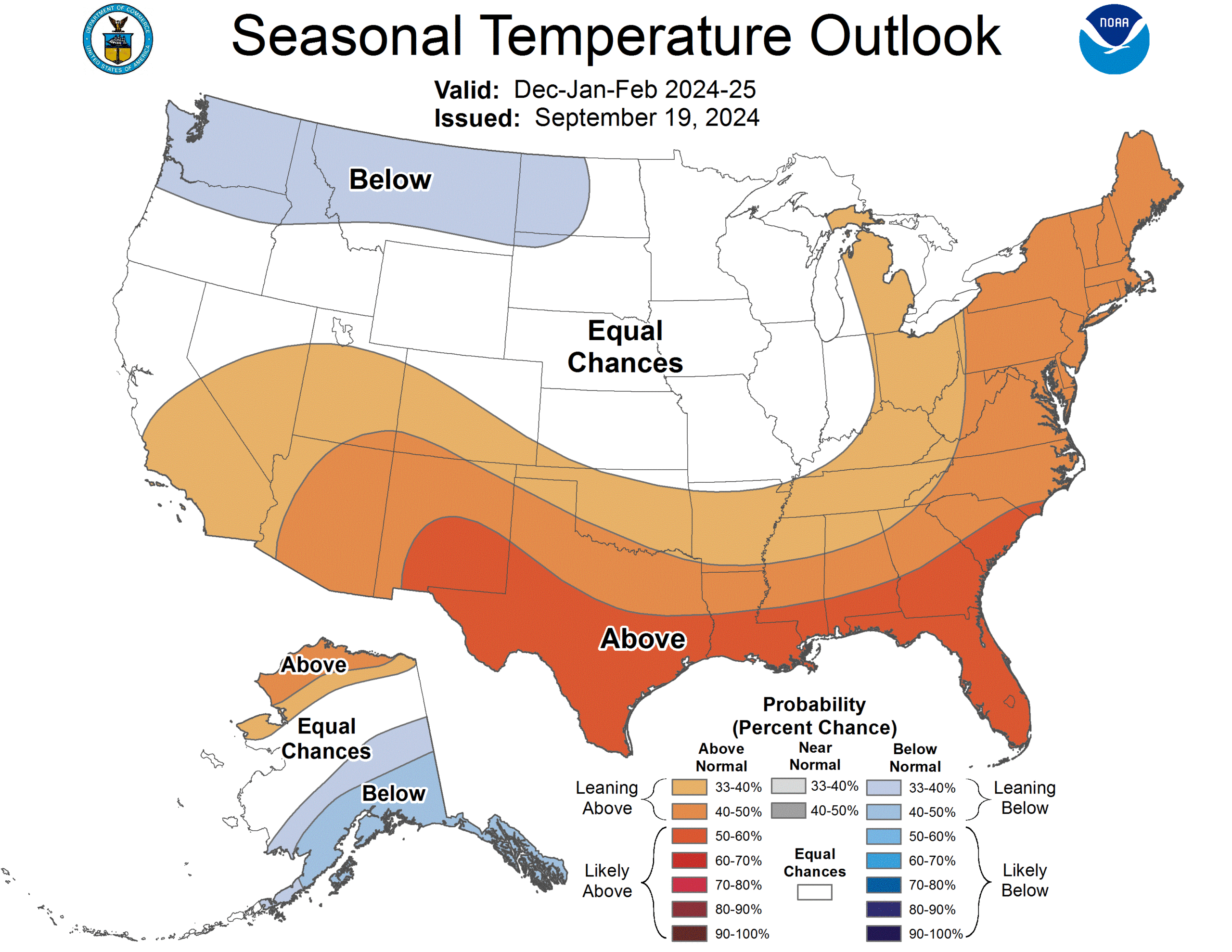
As seen above, the Temperature Outlook for December 2024 through February 2025 looks similar to the map issued last month, with a few changes in the American Southwest and Northwest. The Southwest now sees an extended block of above-average temperatures, stretching across most of the U.S. southern border. The Pacific Northwest (PNW) is showing a wider range of below-average temperatures stretching farther east, but with less severity on the western coast. Alaska remains primarily the same.
Unfortunately for skiers in northern New Mexico and Arizona, as well as Utah, Colorado, and Southern California, this extended southern swath of warm temperatures now indicates that these states will possibly see warmer temps earlier in the ski season. It’s certainly not a guarantee, but is leaning above average with a probability of 30-40%. For the PNW, the forecast remains relatively the same, with cold early season temps projected.
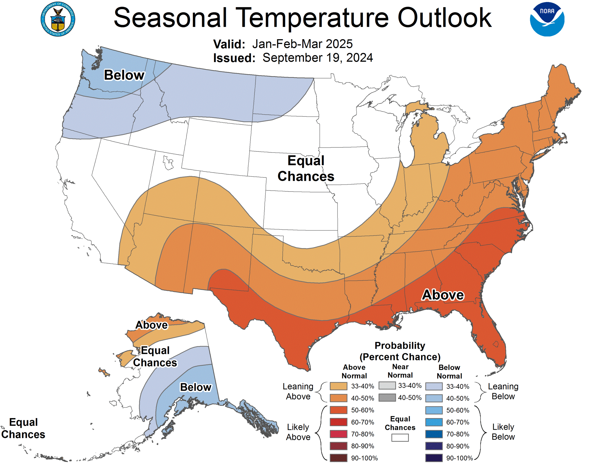
Moving later into winter 2025, the Temperature Outlook for January through March of 2025 shows a few notable changes compared to the forecast from August. The Four Corners area is now covered in above-average temperatures, with a probability chance of 40-50%. Alaska looks very similar to what was previously projected, with the Southeast coast of the state now seeing a larger area covered by below-average temperatures with a probability of 40-50%. There are several mountain ranges with world-class heli-skiing nearby, including the Chilkat, Chugach and Tordillo Mountains. The precipitation in that area doesn’t look as promising, but that certainly doesn’t mean it’s a lost cause if you’re planning a trip up there.
In the PNW, below-average temperatures are sweeping from the West Coast to North Dakota, with the highest probability (40-50%) sitting above Washington state. Oregon, parts of Idaho and most of Montana are now included in this cold bubble as well. As often happens in La Niña winters, this corner of the U.S. is shaping up for a cold one. When combined with the Precipitation Outlooks listed below, it seems like that area of the country is in for a promising winter, filled with cold smoke pow, and frozen smiles.
Precipitation Outlooks
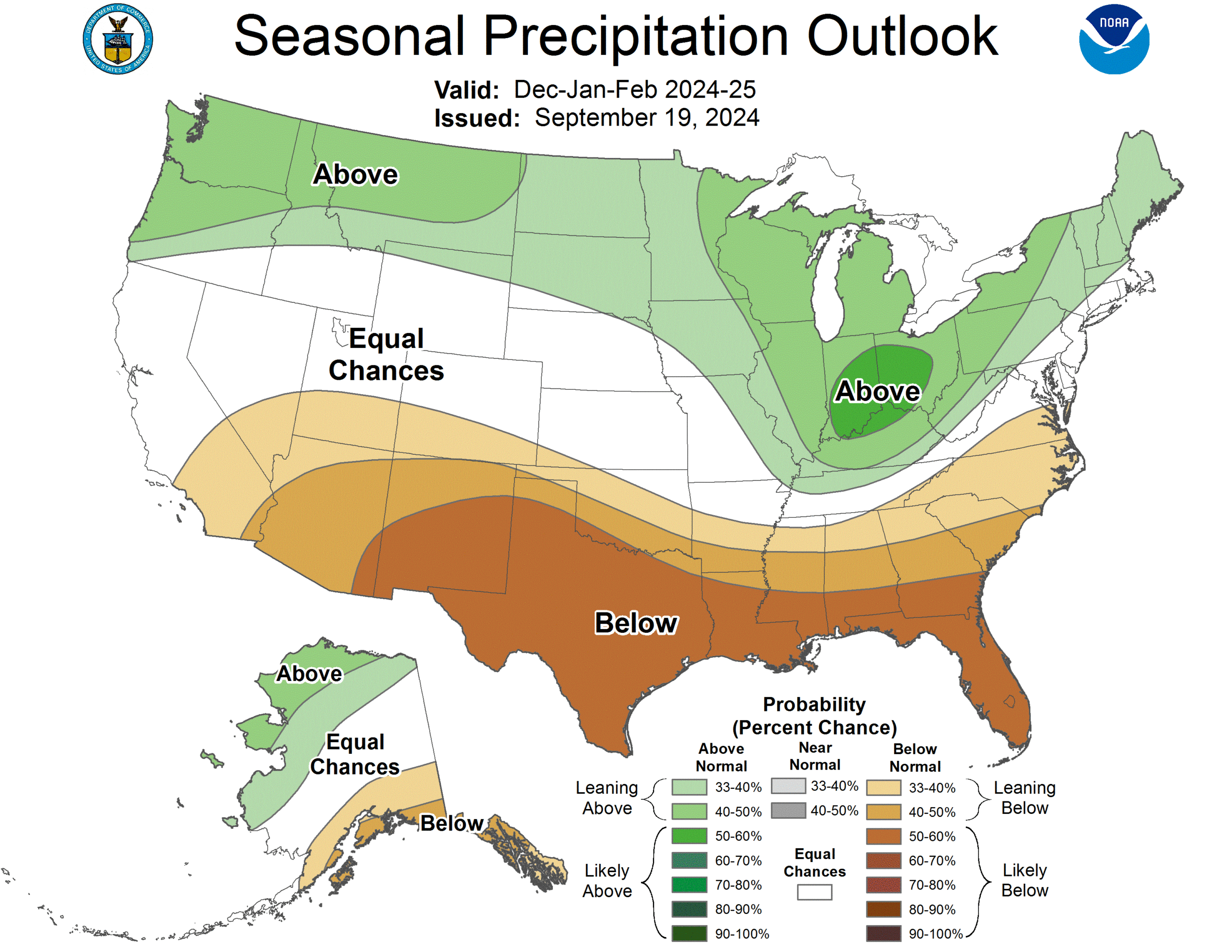
Praise be the frozen water! The Precipitation Outlook for December 2024 through February 2025 (listed above) is divided nearly perfectly throughout the middle of the Continental United States. Compared to last month’s forecast, the map now shows a wider area for above-average precipitation throughout the Northern-most States, with high chances of extreme precipitation in Washington, Oregon, Idaho and Montana, as well as around Michigan, Indiana and Ohio.
Midwest and East Coast skiers, now is your time to rejoice! Well, maybe save that celebration for when you’re knee-deep in pow or skiing late into the season thanks to excess snowfall, but still, it’s looking optimistic for you. Colorado, Utah and Wyoming, there’s no need to lose hope yet. It might not be your best season on record, but it still looks good, with Equal Chances forecasted.
Turning our attention towards the Southern Colorado resorts, Taos and Arizona Snowbowl, the forecast looks less promising. That being said, freak storms here and there are notorious for gracing the region in the depths of winter, so it can often be a good call to head over there for a storm chase and no crowds.
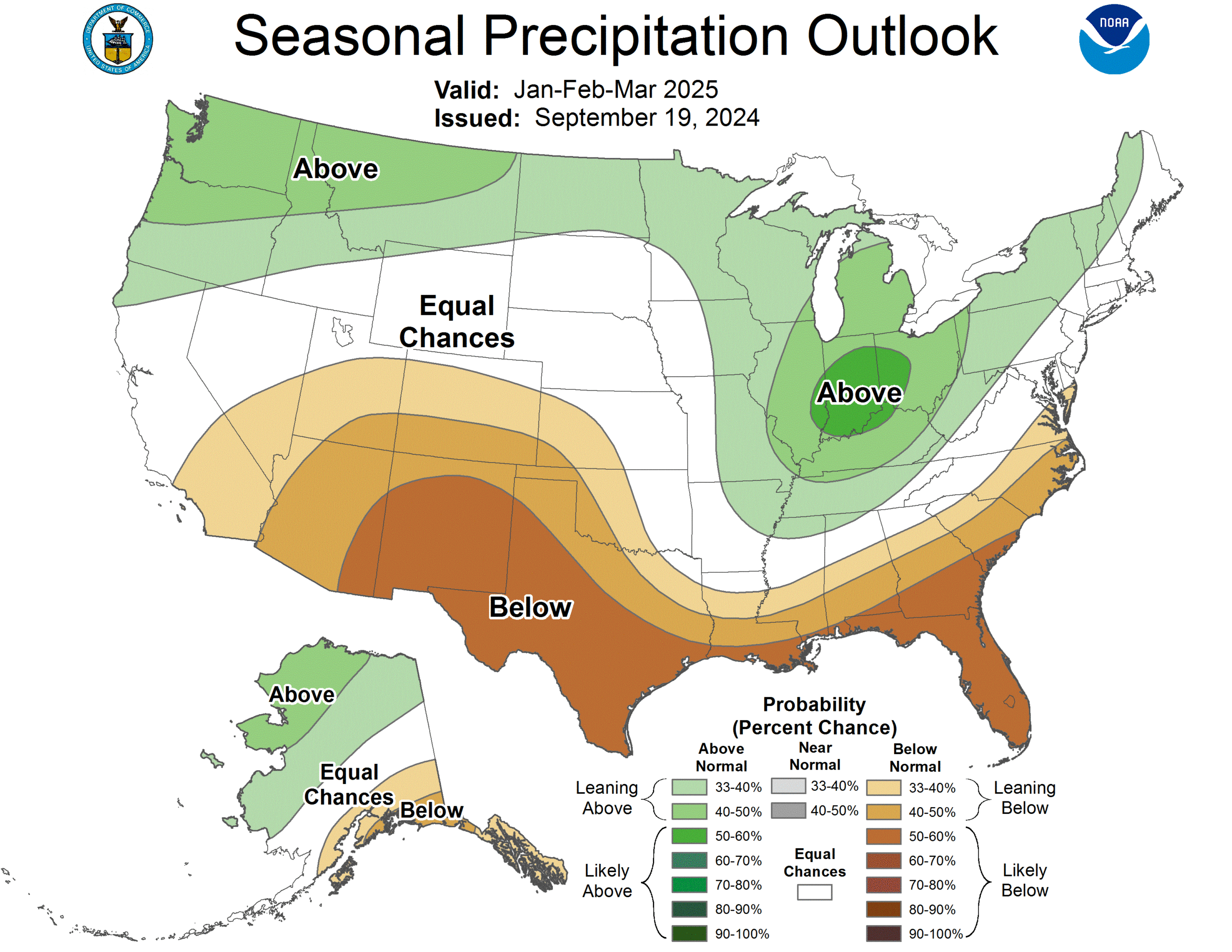
Moving into our last graph for this round of predictions, we can see relatively the same forecast as we last saw. However, changes can be seen in the PNW, the Northern East Coast and Alaska. On the East Coast, the area of above-average precipitation has moved inland, which doesn’t appear like it will have much of an effect on most resorts in the area. The Northern stretch of the U.S. can expect above-average precipitation through the bulk of the winter months.
The precipitation prediction for the American Southwest looks similar to the August forecast, with below-normal precipitation expected in Colorado, Utah, New Mexico and Arizona. Southeast Alaska also shows a larger area of below-average precipitation. This area area receives copious amounts of snow every winter, so it’s still worth heading out if you’ve been eyeballing a trip north.
What the Hell Does This All Mean?
This is now the third NOAA 3-Month Outlook that we’ve covered, and since the first one debuted in July, it’s been clear that the experts are anticipating a La Niña winter. The developing forecasts that have followed all indicate standard La Niña events in the United States, with the southern portion of the country expecting higher temperatures and lower amounts of precipitation than normal, and the northern portion of the country looking at lower temperatures and high amounts of precipitation than normal.
Of course, these predictions are never set in stone. It’s important to point out that NOAA stated, “chances of a moderate to strong La Niña are currently less than 50% through the Fall and Winter. ENSO-neutral conditions are favored to re-emerge by the February-April (FMA) 2025 season.” This means that while we might be in for a La Niña winter, we probably won’t see weather events that mimic the most extreme scenarios possible.
As we move towards fall, and our anticipation for winter reaches feverish points, we have a few FREESKIER takeaways from the latest round of forecasts. We’re not professional meteorologists, but after reading through data from NOAA for the last few months, we feel slightly under-qualified to say the following –
- The PNW (and most of the Northwest) will have a year. Head to Mount Baker if you’ve been thinking of it. Of course, going into Western Canada during a La Niña winter is always a good call as well. The area is usually known for getting lots of heavy snow, with powder mornings turning into cake batter cement snow afternoons before your eyes. However, these colder temperatures should ensure that dry snow makes its way to the western reaches of America this winter. After Idaho and Montana saw poor winters over the last two years, it’s time for a much-needed refresh.
- Hit the Mitten. That’s right. If you’re a Midwest skier looking for an adventure that isn’t far and won’t break the bank, head to Michigan. Some true legends of the sport have come out of this state, such as Mike Hornbeck, Mike King and Josh Daiek, speaking to how fun the skiing can be. While temperatures seem likely to fluctuate, prolific moisture seems probable.
- It might be a good year to ski the east… maybe. We’re only throwing that “maybe” in there to be cautious. BUT, things certainly look promising for skiers in New Hampshire, Vermont, Upstate New York and Maine. This portion of the country also produces some incredible skiers who don’t get their fair share of deep fluff. That rarity is part of what makes an Ice Coast pow day so special. That being said, we’d be pretty stoked if all our friends out east got ten (or a hundred) more laps in waist-deep snow this year.
- Central and Southwestern states, do not give up hope. Colorado and Utah, we’re looking at you. As the old saying goes, it ain’t over till it’s over, and it sure as hell isn’t over! No, the forecast does not look promising for these spots, but sleeper storms are never out of the realm of possibility. Every skier has seen evidence of the magic that a lake effect-fueled storm can deliver for Utah’s Cottonwood Canyons. And who hasn’t heard tales of snow that barrels over your head after a multi-day dump at Wolf Creek in Southern Colorado?
No matter what this season holds for you, another season making turns is better than not. As the ski season draws closer, we’ll be sure to keep you updated on NOAA predictions and current weather patterns throughout North America so that YOU can line up the ski trip of all ski trips this winter.
Full NOAA Summary:
El Niño Southern Oscillation (ENSO)-neutral conditions are present, as
equatorial sea surface temperatures (SSTs) are near-to-below average in the
central and eastern Pacific Ocean. During the last four weeks, negative SST
anomaly changes prevailed across the western and central equatorial Pacific
Ocean. As such, a La Niña Watch is in effect, with La Niña favored to emerge in
September-November (SON) (71% chance) and is expected to persist through
January-March (JFM) 2025. However, chances of a moderate to strong La Niña are
currently less than 50% through the Fall and Winter. ENSO-neutral conditions
are favored to re-emerge by the February-April (FMA) 2025 season.

The October-December (OND) 2024 temperature outlook favors above normal
temperatures for the southern two-thirds of the Contiguous United States
(CONUS), the eastern third of the CONUS, and northwestern Alaska. The largest
probabilities (greater than 60 percent) of above normal temperatures are
forecast across much of the Southwest and parts of the Rio Grande Valley and
southern High Plains. Conversely, a weak tilt toward below normal temperatures
is indicated for Southeast Alaska, parts of the southern Mainland, and parts of
the Alaska Peninsula. The OND 2024 precipitation outlook depicts enhanced
probabilities of below-normal precipitation amounts across much of the
south-central and southwestern CONUS as well as most of Southeast Alaska and
parts of the southern Mainland.

The greatest chances (greater than 50 percent)
of below-normal precipitation are forecast for much of the Rio Grande Valley
and much of the Southern High Plains, where probabilities of below exceed 50
percent. Above-normal precipitation is more likely for the northwestern CONUS,
the Great Lakes and Northeast, and much of northwestern Mainland Alaska. Equal
chances (EC) are forecast for areas where probabilities for each category of
seasonal mean temperatures and seasonal accumulated precipitation amounts are
expected to be similar to climatological probabilities.
