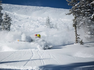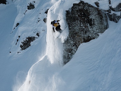
Featured Image: Gabe Rovick | Skier: Max Kirshenblatt
The United States National Oceanic and Atmospheric Administration (NOAA), one of the most trusted meteorology sources in the world, publishes weather prediction updates each month. Read on for the official report from NOAA, descriptions, and our takeaways for where YOU can score blower pow days this winter.
This is a look at NOAA’s predictions published August 15th for December 2024 through March 2025.
It’s important to note that while these predictions are based on detailed scientific data, backed by months of pattern analysis and years of research, they are not precise predictions for specific states. However, they can offer a real look at what general regions may look like this winter. Plus, they’re fun to go through so what’s the harm in fantasizing about a few deep turns this winter? No judgment here.
Before we explore the current predictions, let’s examine what some of the complicated terms mean.
NOAA makes upcoming winter weather predictions for North America based on patterns and data readings in the Pacific Ocean. This is called the ENSO (El Niño / Southern Oscillation) climate pattern. ENSO refers to the general climate patterns in the Pacific Ocean and does not indicate an El Niño cycle, despite the name. Yes, it’s confusing. From this pattern, they can measure temperature anomalies that are developing. These predicted cycles are indicated by terms you’ve likely heard before; El Niño and La Niña.
“El Niño and La Niña represent opposite extremes in the El Niño/Southern Oscillation (ENSO). The ENSO cycle refers to the coherent and sometimes very strong year-to-year variations in sea-surface temperatures, rainfall, surface air pressure, and atmospheric circulation that occur across the equatorial Pacific Ocean” – NOAA
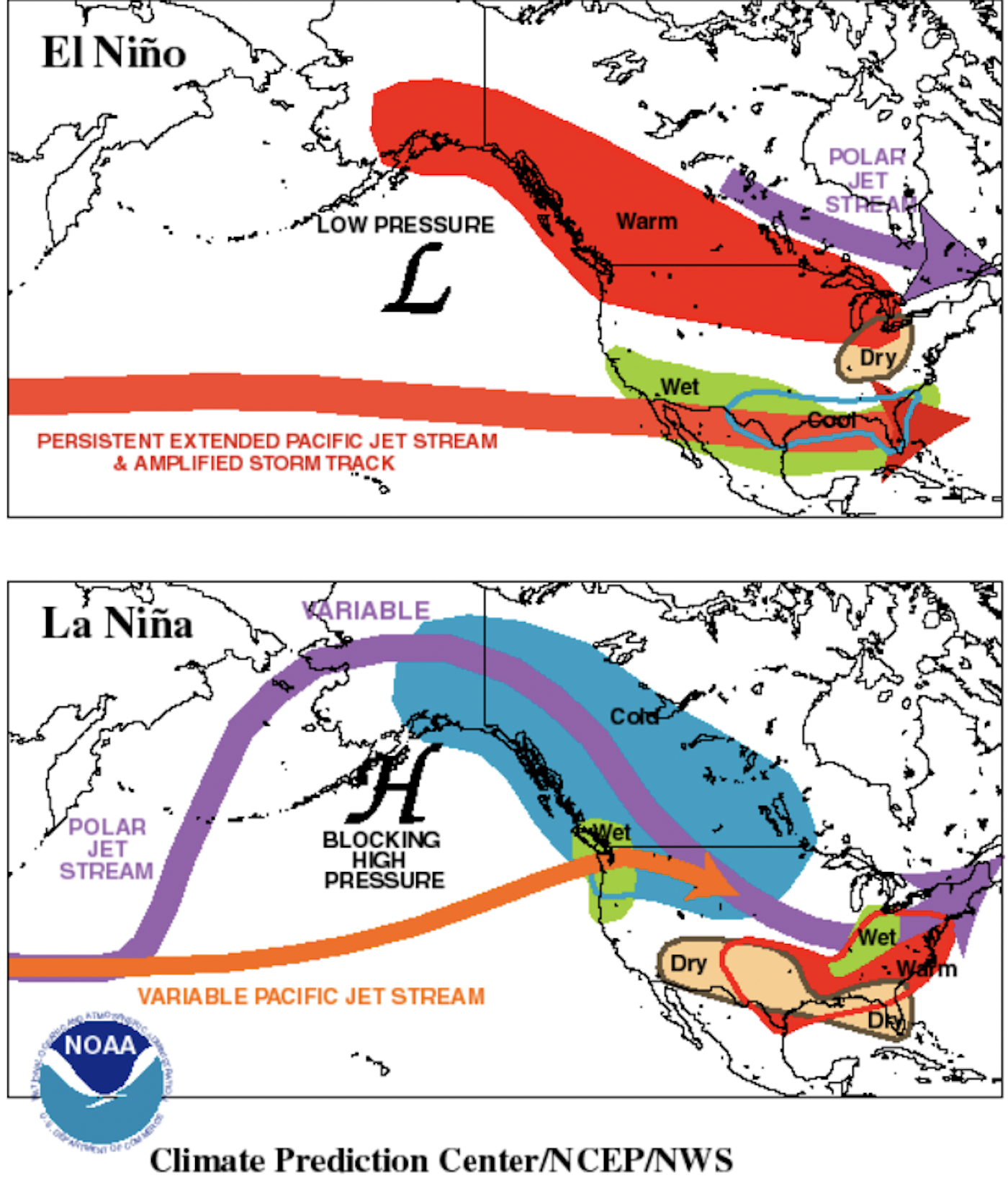

El Niño is characterized by warmer tropical Pacific ocean surface temperatures.
Typically lasts around 9-12 months and is more frequent, according to NOAA.
La Niña is characterized by cooler than normal tropical Pacific ocean surface temperatures.
Typically lasts 1-3 years. According to NOAA, durations of either can vary greatly, even by a matter of years.
Low-pressure systems pull air in and are associated with El Niño cycles of warm Pacific ocean surface temperatures. This system pulls the Pacific jet stream “south of its neutral position,” according to NOAA, which brings moisture to the southern U.S. and warmer temperatures to the north.
High-pressure systems push air out and are associated with La Niña cycles of cooler Pacific ocean surface temperatures. This system pushes the Poplar and Pacific jet streams north, bringing dryer conditions to the Southern United States, and colder air with above-average precipitation to the north.
La Niña Development Continues to be “Favorable”
As the winter months draw near, scientists better understand the current trends surrounding the ocean, jet stream and beyond. The previous climate prediction from NOAA, released in mid-July 2024, issued a La Niña Watch. This declaration stated that the current patterns suggested a 70% chance that La Niña would emerge during August – October of this year in the Northern Hemisphere, and a 79% that it would persist into the winter months of 2025. While those odds have shifted slightly, the data is still favoring La Niña.
“La Niña is favored to develop during September – November (66% chance) and persist through the winter of 2024 – 2025 (near 70% chance).” – NOAA as of 8/15/24
As covered above, this means that Pacific ocean surface temperatures are trending towards cooler than normal. High-pressure systems block the polar jet stream, forcing it north of the Western United States. The cold air meets moisture along the west coast of North America, usually delivering plenty of snow to the Pacific Northwest (PNW). Of course, this weather system has other outcomes across the U.S. that we’ll explore below.
Temperature Outlook

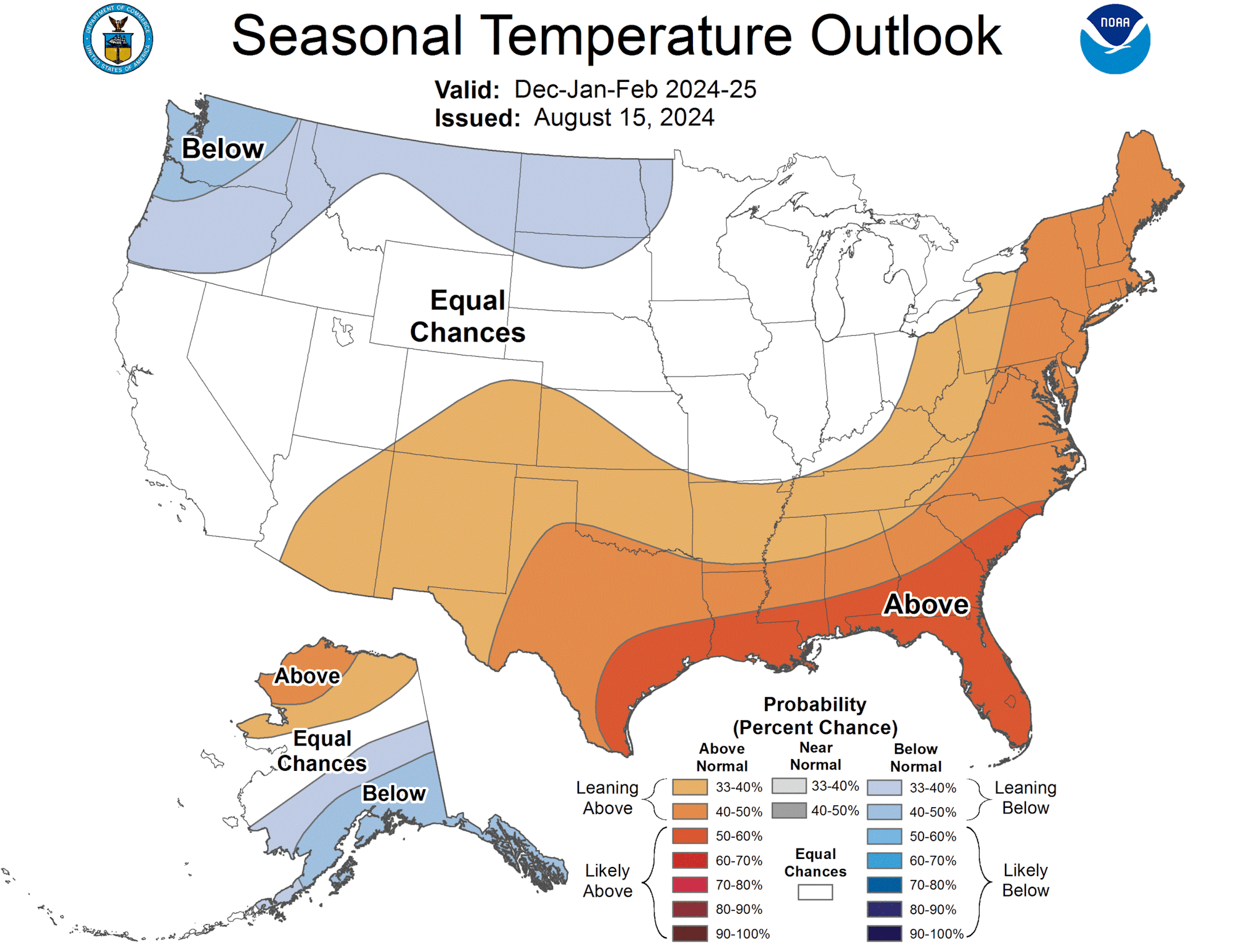
U.S. Temperature Outlook for December 2024 – February 2025
The Temperature Outlook for December through February, as seen above, looks similar to the one issued earlier this summer. There are slight differences in the American Southwest, however, with more of Arizona, New Mexico and Southern Colorado favored to receive slightly above-average temperatures. If you’re a Snowbowl, Taos, Wolf Creek or Telluride skier—don’t fret, this doesn’t mean the end of your season, but it is something to watch out for.

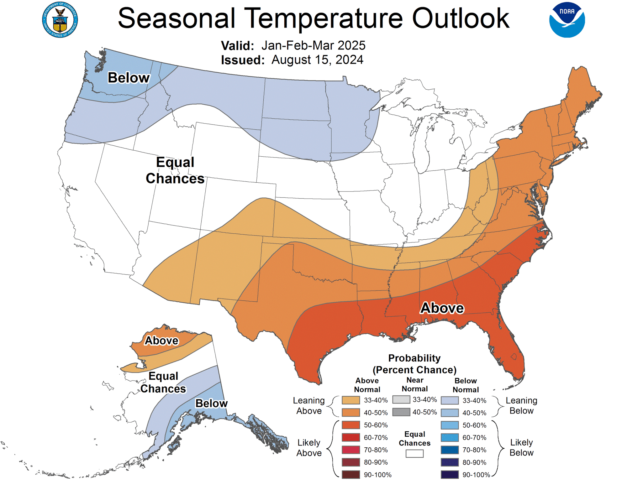
U.S. Temperature Outlook for January – March 2025
Similarly, the Temperature Outlook for January through March 2025 has changed only in the American Southwest when compared with the outlook released earlier this summer. The upper areas of the PNW, specifically central Washington, southeast Alaska and parts of Montana through the Midwest should expect cold temperatures.
Heavy, moisture-laden pow days are usually the norm along those western coastal regions. However, these dropping temperatures could lead to a multitude of blower, dry powder storms rolling through. PNW skiers rejoice! And of course, if you’re a leathery sun-bather in Flordia, you’re going to like this forecast, too.
Precipitation Outlook

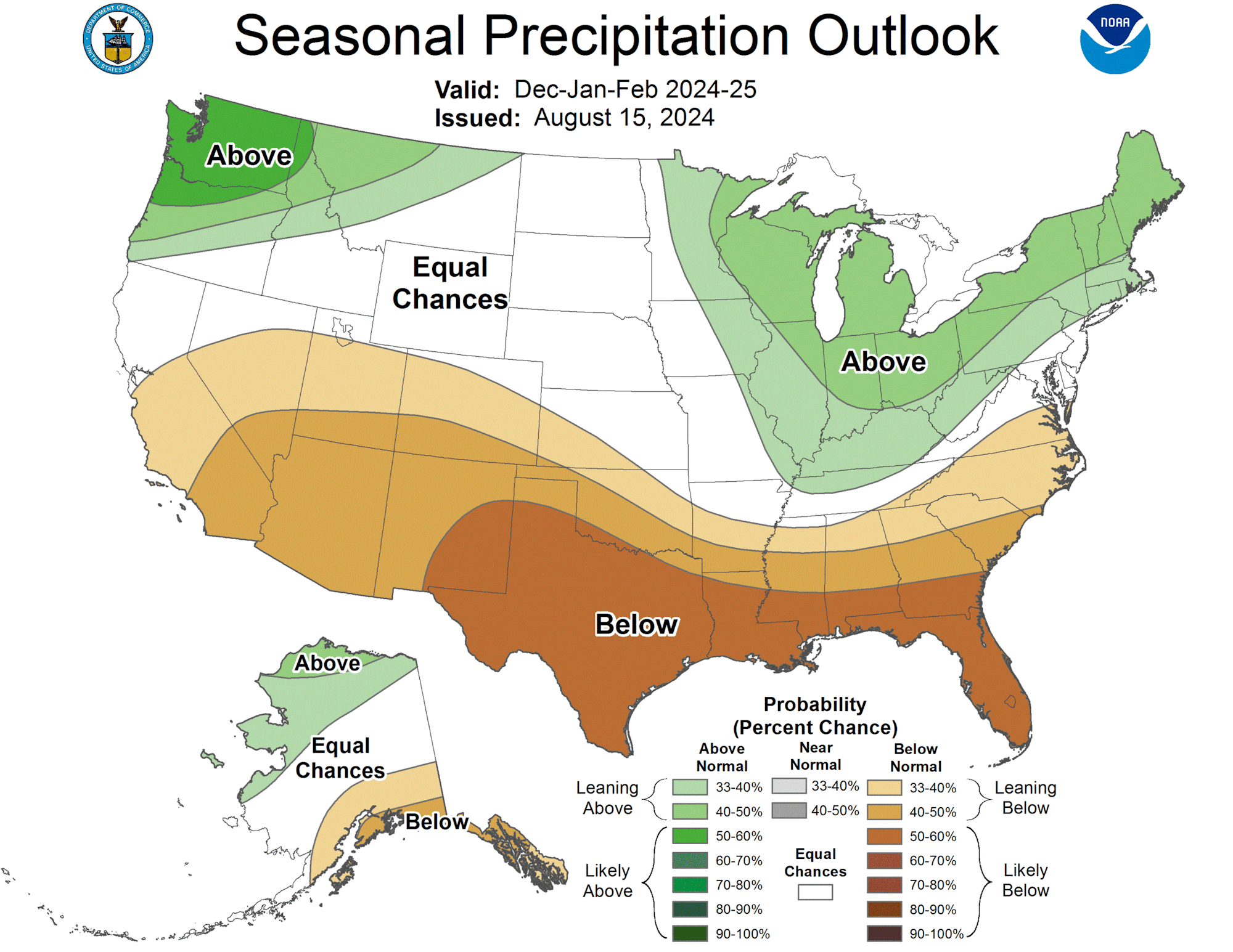
Precipitation Outlook for December 2024 – February 2025
From December of this year through February 2025, NOAA is anticipating heavy precipitation along the Pacific Northwest region, as well as around Michigan up through Maine. This outlook pairs well with the below-average temperatures expected in the PNW, but southeastern Alaska is expected to see below-average precipitation early in the winter.
The combination of cold temps and lots of precipitation in certain areas means that, if everything goes according to plan, Washington, Oregon, Idaho and western Montana mountains should see a substantial start to winter. This would be huge for the area, as they haven’t had consistent snowfall in the early season for some time. Copious amounts of snow might blanket the likes of Mt. Baker, Stevens Pass and more.

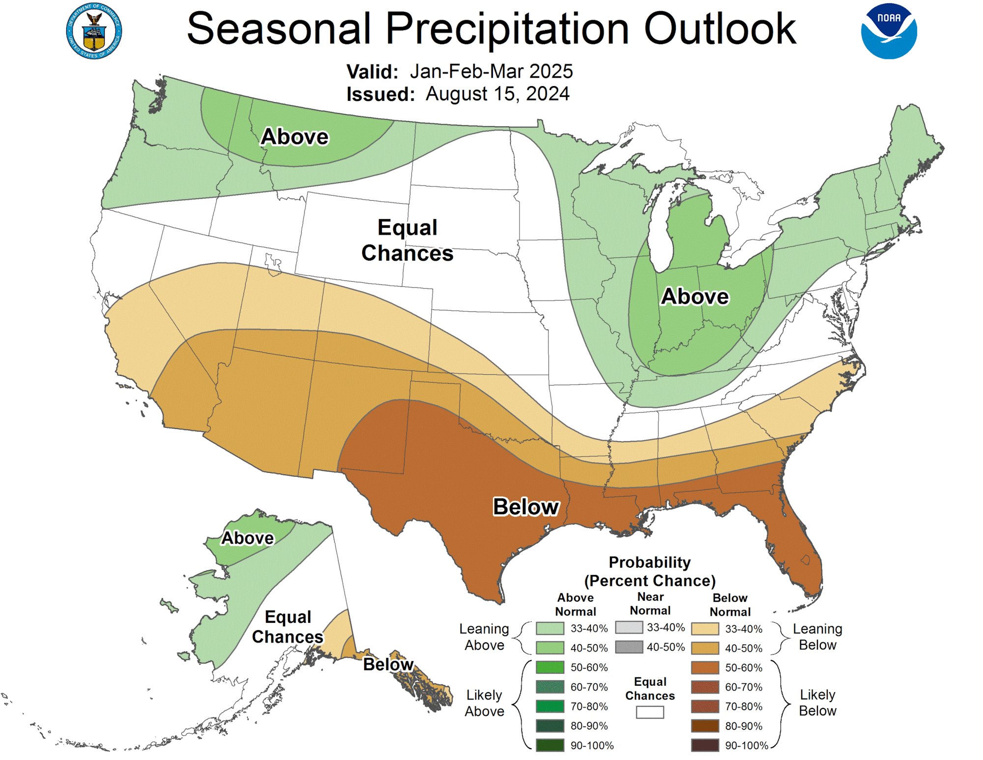
Precipitation Outlook for January – March 2025
An odd combination is visible in the American Northeast, where above-average temperatures are expected to collide with above-average levels of precipitation. What will this bring? It’s hard to say. If you’re an Upstate New York, New Hampshire, Vermont or Maine powder hound, we recommend dialing up your local meteorologist to inquire… or just making several offerings to Ullr every night before winter. Whatever floats your boat.
What the Hell Does This All Mean?
It’s a great question. These predictions are just that—predictions. There’s no guarantee as you look state by state. However, the general trends usually carry truth to them. After two back-to-back NOAA updates featuring a La Niña Watch initiation followed by favorable La Niña patterns, it looks like we’re in for a La Niña winter.
Historically, La Niña years bring very favorable winters to skiers in the northwest corner of the U.S. Take a look at the supporting data from Mt. Baker’s record-setting snowfall winter of 1998/99. Cooler ocean temperatures in the Pacific push the jet stream north, gathering cold air and plenty of moisture. This tends to drop above-average amounts of snow from Oregon up through British Columbia while leaving the southern regions of the United States with higher temperatures and less moisture.
Northern Colorado, Utah, Wyoming and the Central Rockies at large, sitting in the middle of the country, are much more of a toss-up. Of course, if you’re a frequent skier of the Cottonwood Canyons, you can always rely on a little bit of lake effect to boost your powder odds. But in all, if you’re looking to start planning that snorkel-deep powder expedition, keep your eyes on the PNW.
As winter approaches, we’ll be sure to break down more forecasts as they arrive with increased frequency and accuracy so that YOU can start lining up those sick days and booking trips to wherever the snow may fall.
Full NOAA Summary:
El Niño Southern Oscillation (ENSO) conditions are neutral with equatorial sea
surface temperatures (SSTs) above average in the western Pacific, near average
in the east-central Pacific, and below average in the eastern Pacific. La Niña
is favored to develop during September-October-November (66% chance) and
persist through the winter 2024-2025 (near 70% chance).

The September-October-November (SON) 2024 temperature outlook favors
above-normal temperatures across a majority of the contiguous U.S. with the
largest probabilities (exceeding 60%) forecast for New England and parts of the
Southwest. Increased below-normal temperature probabilities are forecast for
southwestern Alaska, while above-normal temperatures are more likely across
northern Alaska.

The SON 2024 precipitation outlook depicts elevated probabilities for
above-normal precipitation along the East Coast, parts of the Pacific
Northwest, and western Alaska. Below-normal precipitation is favored for the
Central to Southern Great Plains, Central Rockies, Southwest, southern
California, and southern Alaska.