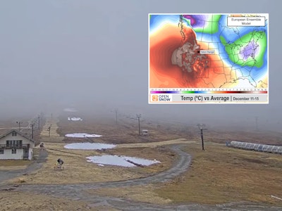
Here is a quick and dirty look at conditions expected across the country over the next week. Obviously, snowfall and other weather patterns can vary greatly within regions, so use this report as a general guideline. However, with more resorts opening over last weekend and moisture expected across North America, we are cautiously optimistic about improving conditions for all areas.
The East
A system moves through today with the potential for scattered snow showers prior to clearing before a second system hits the area at the end of the week. This second low pressure is warmer, which will raise snow levels and could result in rain mixed with snow.
Midwest
The Midwest also sees some moisure this week, with colder temperatures producing freezing rain which should turn to snow by the end of the week.
Rocky Mountains
Colorado"™s Front Range is expected to see the first snow of the year today, substantially later than the average of a mid-October date for the first snowstorm. The central and northern mountains should see light snowfall throughout the week, with the southern Rockies (Taos, Telluride, Silverton) getting the brunt of the action (but no major accumulation) from a low pressure system that moves through the region today. Expect sun and warming temperatures by the weekend.
California and Pacific Northwest
Warmer temperatures coupled with moisture will plague the Pacific Northwest, with rain and rain/snow mix in the Cascades. California will also see a shot of moisture with snow levels dropping to 6,000 feet as temperatures fall. There is another chance for snow later in the week, but expect the weekend offer diminished chances of moisture.
![[GIVEAWAY] Win a Head-to-Toe Ski Setup from IFSA](https://www.datocms-assets.com/163516/1765920344-ifsa.jpg?w=200&h=200&fit=crop)
![[GIVEAWAY] Win a Legendary Ski Trip with Icelantic's Road to the Rocks](https://www.datocms-assets.com/163516/1765233064-r2r26_freeskier_leaderboard1.jpg?w=200&h=200&fit=crop)
![[GIVEAWAY] Win a Legendary Ski Trip with Icelantic's Road to the Rocks](https://www.datocms-assets.com/163516/1765233064-r2r26_freeskier_leaderboard1.jpg?auto=format&w=400&h=300&fit=crop&crop=faces,entropy)
![[GIVEAWAY] Win a Head-to-Toe Ski Setup from IFSA](https://www.datocms-assets.com/163516/1765920344-ifsa.jpg?auto=format&w=400&h=300&fit=crop&crop=faces,entropy)