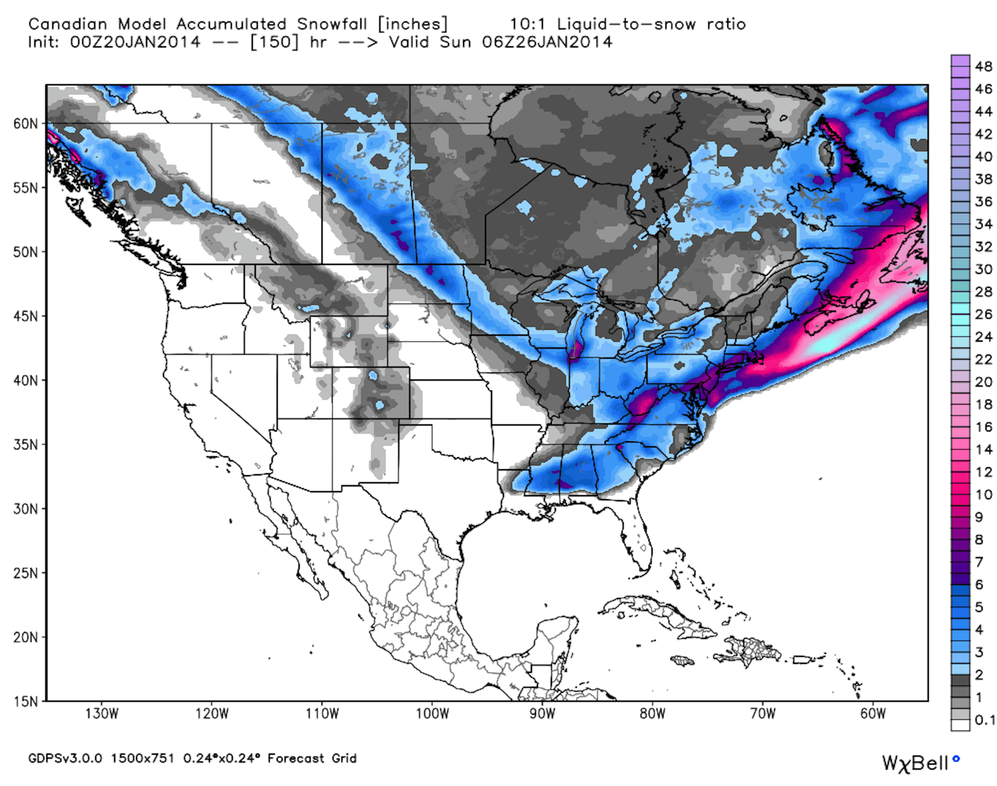

Most people in the mid-Atlantic will wake up to a powder day Wednesday morning, notably areas in Maryland, Pennsylvania, and West Virginia. While OpenSnow.com is calling the event the biggest snow storm in three years for the mid-Atlantic, the most snowfall will occur between metro Philadelphia and metro Baltimore, with about six inches falling in the mountains surrounding that corridor.
Accumulation forecasts for the United States. Image courtesy of OpenSnow.com.
A big storm is set to hit the New England area, but will stand to benefit the southern states more than the northern portions of the region with higher elevation resorts. Wednesday and Thursday are both great days to call in sick if you happen to live in Connecticut, Massachusetts, Rhode Island or southern New Hampshire.
The Northeast
The storm set to pound the mid-Atlantic will track up the coast on Tuesday night, hitting coastal ski areas in New England throughout the day on Wednesday. Blue Hills, located in eastern Massachusetts, could see 6 to 10 inches Tuesday night, and an additional 1 to 3 throughout the day on Wednesday. Bradford, Nashoba Valley, Ski Ward, and Wachusett (located in western Massachusetts) could all see 4 to 8 inches on Tuesday night and 1 to 2 more on Wednesday. Tiny Yawgoo Valley, located in Newport, Rhode Island, is projected to see 6 to 10 inches on Tuesday night, and 1 to 3 more on Wednesday.
Accumulation projections for the Northeast. Image courtesy of OpenSnow.com.
Southern Vermont ski areas like Magic Mountain and Mount Snow should see a bit of accumulation, 1 to 3 inches, on Tuesday night, but the next chance for some snowfall for the Green Mountain State will take place on Saturday. Most of the state should see 1 to 3 inches on Saturday, and 1 to 2 more on Saturday night, setting up for a nice powder day on Sunday.
New Hampshire should see decent accumulations throughout the night on Tuesday, with an expected 3 to 5 inches falling at Cannon Mountain, Crotched Mountain, Granite Gorge, Loon Mountain, and Waterville Valley, and 3 to 7 expected at Pats Peak. More snow will move into the area on Saturday, with another 3 to 5 projected for Cannon, Loon, and Waterville Valley.
Maine will also get in on the powder party. Powderhouse Hill (Maine’s only lift accessed ski area along its sea coast) can expect 2 to 6 inches Tuesday night with another couple of inches on Wednesday, and Sunday River should see 2 to 4 inches on Tuesday night. On Saturday and Saturday night, ski areas like Sugarloaf, and Saddleback could see anywhere from 2 to 6 inches of accumulation, meaning Sunday should be prime.
The New England daily snow report for OpenSnow.com is written by Brian Clark.
The Mid-Atlantic
Most of Pennsylvania will see solid snowfall totals by Wednesday morning. Bear Creek is expecting 5 to 11 inches of snow throughout Tuesday and Tuesday night, Blue Mountain is projected to have 3 to inches, Liberty Mountain 5 to 10 inches, and Spring Mountain 5 to 13 inches. As the week progresses, Saturday appears to be the next chance for some snowfall, with most of the state looking at 1 to 4 inches of total snow by Sunday morning.
Maryland’s Wisp Resort should see 5 to 10 inches of snow by Wednesday morning, and an additional 1 to 5 inches from Saturday to Saturday night.
West Virginians will have a powder day on Wednesday morning, as Canaan Valley, Snowshoe, and Timberline, should see anywhere from 6 to 13 inches. Another chance for snow will come Thursday night for Snowshoe, and then again on Saturday.
Check out daily weather reports for the mid-atlantic courtesy of Justin Berk.
Colorado
The week will be mostly devoid of chances for snowfall, with the exception of Wednesday and Wednesday night. Areas that benefit from an easterly wind, like Eldora and Monarch, should see 1 to 3 inches of snow on Wednesday. The moisture from this storm will make its way south on Thursday, and drop 1 to 3 inches of snow at Wolf Creek. Most models show that the ridge of high pressure stationed along the west coast will dissipate around the middle of next week, opening up the possibility for more storms to hit Colorado.
Snowfall accumulations for Colorado from 5 p.m. Wednesday through 5 a.m. Thursday. Image courtesy of OpenSnow.com.
For daily Colorado powder forecasts from OpenSnow founder, Joel Gratz, click here.
The Midwest
Midwestern states should be sitting pretty snowfall-wise for the coming few days. Wednesday night will kick off the action, with 3 to 5 inches projected to fall at Big Powderhorn, Blackjack, Indianhead, with 1 to 3 inches expected for the rest of the state. The chances for snow will persist throughout the week, with a projected 2 to 4 inches set to blanket Alpine Valley Ski Area, Pine Knob, and Swiss Valley on Friday night.
Minnesota ski areas will see 1 to 2 inches throughout Tuesday night, as well as Friday during the day, meaning that Wednesday and Saturday will be the best days for a bit of powder skiing.
Meteorologist Andrew Murray provides daily weather reports for the Upper Midwest.
Utah
The next week looks to remain dry in Utah, with a chance of some snowfall on Wednesday night for the areas in the northern part of the state (Park City, Powder Mountain, Snowbasin, Snowbird, Alta, Brighton, Canyons, Deer Valley), but the state should look towards the end of the month when the high pressure system over the Pacific lifts and makes way for storms to travel east.
Stay up to date on Utah’s weather with daily updates from Evan Thayer.
The Northern Rockies
Montana should see a bit of snow accumulation this week, with Showdown Mountain looking at a surprise 3 to 7 inch powder day throughout Wednesday. Bridger Bowl could also squeeze 1 to 3 inches out of that storm.
In Wyoming, Hogadon, Meadowlark Ski Lodge and Snowy Range should all see 1 to 3 inches of snow throughout the day Wednesday and into the evening. Things will remain relatively quiet weather-wise for the state of Idaho.
Pacific Northwest and Sierra Nevada
The weather in Washington should remain dry for most of the week, with the exception of Tuesday night and Wednesday, when a dusting could fall on Crystal Mountain, Stevens Pass, and Alpental. Oregon will remain dry for this coming week, and California will continue its snow-less streak, but the high pressure ridge sitting along the coast should move out towards the end of the month, allowing for storms to move into the Sierra Nevada.
Check out the full OpenSnow.com forecasts for California, Oregon, and Washington.

![[GIVEAWAY] Win a Head-to-Toe Ski Setup from IFSA](https://www.datocms-assets.com/163516/1765920344-ifsa.jpg?w=200&h=200&fit=crop)


![[GIVEAWAY] Win a Legendary Ski Trip with Icelantic's Road to the Rocks](https://www.datocms-assets.com/163516/1765233064-r2r26_freeskier_leaderboard1.jpg?auto=format&w=400&h=300&fit=crop&crop=faces,entropy)


![[GIVEAWAY] Win a Head-to-Toe Ski Setup from IFSA](https://www.datocms-assets.com/163516/1765920344-ifsa.jpg?auto=format&w=400&h=300&fit=crop&crop=faces,entropy)