So last year, about January probably, my friend Scott mentioned something about this place called Malibu. Not the Malibu that first comes to mind though, not California, instead Scott was talking about Malibu, Canada. He started talking about it and how he and his older bro were going up there this summer. He was trying to convince me to go. Then I heard the price…$800 plus food. Well, needless to say, that idea went out the two story window with a loud crash as it hit rock bottom. So Scott dropped it for a bit. Then a few weeks later he brings it up again. The summer before, 05-06, I had been given the opportunity to canoe along the route Lewis and Clarke took. I declined this trip and regretted it. Looking back on this, I’m thinking, I don’t want to make that mistake again. The next day I tell Scott that I’m interested.
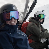
Somehow by the time July rolls around I’ve got my dues paid. Things were tricky getting started, the week before I was supposed to leave for Canada I was hiking a week in New Mexico with some friends. I get back from that trip with four days to clean my equipment and a little R&R. Morning of our flight I meet the crew at the airport; Scott, his older brother Kelly, Holland, Keith, and Lena, and myself James Salter and we take a nonstop flight to Seattle. We land in Seattle and go to rent a car. Easier said than done. With six of us and all our equipment for a week in the backcountry, you could say we needed a car bigger than the Chrysler Pacifica they gave us. So here we are in the Seattle airport trying to figure out how to fit all our stuff into this thing. We finally manage to pack all our bags in, which involved the people sitting in the back seat to get in first and pile the bags on top of them. Sadly, that included me. Finally we get on the road racing 90 miles an hour towards Canada on the freeway. We’re not an hour out, when some smartass decides it would be a good idea to rear end us. Go figure its some 70 year old Asian tourist and his wife. We make an executive decision to just tear off the all ready falling apart bumper and leave it on the side of the road. Insurance will cover it…right? Thankfully we met no snags crossing the border. We make it to the ferry from Horseshoe Bay and take a breather while the ferry crosses the bay. We off load the ferry and arrive in Langdale. In Langdale we pick up groceries for dinner and breakfast the next morning. From Langdale, we drive the 90 kilometres to the Egmont landing. Once there we all crashed. The next morning we got up bright and early to board the ferry, leaving our beloved Pacifica behind.
We arrive at base camp around 10 in the morning after a three hour boat ride, meet our guides; Alison (the sole Canadian), Emily, a Boulder local, and Colin, the lumberjack with a beard like thing on his face. Then get ready to leave in the morning.
A smaller boat picks us up and takes us to the trailhead, looked like an abandoned logging camp. The first five kilometres were fairly easy, uphill, but on the logging road. It was pretty cool, about 4k in we saw an entire herd of caribou cross the road. 1k after that we stopped for lunch right before we had to cross this flooded stream. From there on it was into the mix. Did you know that area is considered a jungle. Yeah, the northwestern jungle, no joke either, this sh*t was thick. Being an Arizona kid, I never had to deal much with mosquitoes, yeah, that sucked. After hiking for a solid eight or nine hours and at least six or seven stream crossings we got to our campsite, cooked dinner and hit the sack.
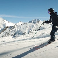
Rise and shine, our second day we broke tree line and hit snow. I was stoked, having been deprived of the beautiful fluff since March I got a little teary eyed. We hiked up through the Yashir Forest and set up tents on the shore of Yashir Lake with daylight to spare. The next morning we all took a crash course in ice axe safety. We started our trek up a ridgeline that would take us to our summit in another day. We debated where we wanted to make our camp for the night, some wanted to stop sooner than later, others wanted to grin and bear it and continue to a higher site with a view of the summit. We decided to continue to the point, definitely worth the extra hike. According to the guides it was the most wanted campsite in the range. The view was awesome, we could see the entire inlet below us as the sun set over the mountains in the distance.
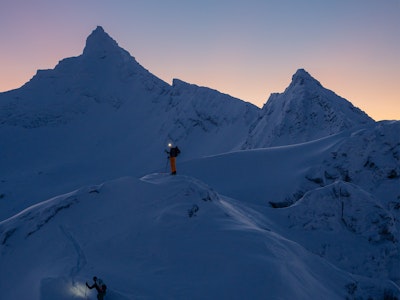
Theoretically, it was summit day, but, as the mountains would have it, and it being early summer and the snow still melting, what with cornices and cliffs and such, you could probably say with confidence that the pre- planned day went bad. Thinking we had maybe a four hour day ahead of us, we didn’t really rush ourselves that morning. Looking back, thats regrettable, but, you know, it is what it is. We’re not hiking for 45 minutes when we hit our first obstacle. Normally, the way we were supposed to go would have been through what was now a large snowpack. Not enough of the snow had melted and was blocking our way, theres not really a way to get around it because on either side are sheer faces. Eventually our guides decide we can climb down the opposite side of this snow wall. Once thats accomplished we keep hiking…temporarily, turn the corner, basically same problem, just different situation. Again, the snow hadn’t melted and was blocking the way around this cliff. The snow tapered down this cliff to the point where we could crawl on top of the cliff, under the cornice to the top of the cliff. That took a while, a long while at that. Give it another hour and we finally reached the summit.
As we reached the top the sun set. It was sick. Since we were so far North, the sun didn’t set till 11 or 12ish. For some reason, I don’t think this hit us all the way it should of. As we prepared to descend down the opposite side of the summit, we all grabbed headlamps out of our packs. The down climb was easily 50 degrees, and we made it facing the slope kicking steps in a single file line. Finally everyone made it down and we hiked another 15 minutes to our next site. Easily 3:00 in the morning by the time we crashed.
Next morning found us in a daze, in need of more sleep, however we had to get up and move. That was a sad day, leaving snow behind us and entering the bush once again. For the better part of the hike we followed a seasonal stream of glacial runoff down the mountain. Wet, muddy, humid, and slick were some of the prime words of the day, among other choice words showing our crew’s vast knowledge of the English language. We arrived at our site enveloped by trees and mosquitoes. Best put this day behind us.
The boat was picking us up at noon at the docks where we started, having completed a 40 mile loop including the summit, we were all smiles as we reached the logging road and headed for basecamp.
At basecamp we all took well deserved and more importantly well needed showers. We said goodbye and boarded the boat down the inlet. However, not before stuffing my face into a specialty 10 scoop ice cream dish, come on, live a little right? Definitely worth the bills.
Sweet, well I hope whoever reads this enjoyed it, oh, and for the record, all those mountains up there are public land, serious backcountry opportunity, anyone with the equipment and the knowledge should definitely check it out, gnarly sh*t.
Peace.
Trip of a Lifetime
January 16, 20087 min read
Trending Stories
![[GIVEAWAY] Win a Head-to-Toe Ski Setup from IFSA](https://www.datocms-assets.com/163516/1765920344-ifsa.jpg?w=200&h=200&fit=crop)
![[GIVEAWAY] Win a Legendary Ski Trip with Icelantic's Road to the Rocks](https://www.datocms-assets.com/163516/1765233064-r2r26_freeskier_leaderboard1.jpg?w=200&h=200&fit=crop)
Recent Articles
![[GIVEAWAY] Win a Legendary Ski Trip with Icelantic's Road to the Rocks](https://www.datocms-assets.com/163516/1765233064-r2r26_freeskier_leaderboard1.jpg?auto=format&w=400&h=300&fit=crop&crop=faces,entropy)
[GIVEAWAY] Win a Legendary Ski Trip with Icelantic's Road to the Rocks
Manon Loschi Crushes in First Film "ENDORPHIN"
December 19, 2025
Videos

Buckles vs BOA on Ski Boots in the FREESKIER Gear Lab
December 18, 2025
VideosGear
Half Skiing, Half Staying Alive with Nikolai Schirmer
December 17, 2025
VideosStories
From Flooding to Feet of Pow, Variable Start to Winter 2025/26
December 17, 2025
NewsStories
![[GIVEAWAY] Win a Head-to-Toe Ski Setup from IFSA](https://www.datocms-assets.com/163516/1765920344-ifsa.jpg?auto=format&w=400&h=300&fit=crop&crop=faces,entropy)
[GIVEAWAY] Win a Head-to-Toe Ski Setup from IFSA
December 16, 2025
Gear
How to Buy Your Next Pair of Used Skis
December 16, 2025
Stories
onX and Griffin Post Shine Light on Public Lands in "Inaccessible"
December 11, 2025
VideosStories