The latest weather forecasts from OpenSnow.com will have folks in the Pacific Northwest rejoicing, with chances of snowfall coming all week and through the weekend. Utah, Wyoming, Montana, and Colorado will all look to get in on the action as well.
Pacific Northwest
The PNW is going to get hammered this week. Oregon’s chances for snow will start Tuesday night, with a chance of 2 to 5 inches at most areas in the state. The snow is projected to keep coming down all the way until Thursday night for ski areas like Mount Bachelor (up to 20 inches by Thursday night), Mount Hood Meadows (up to 51 inches by Friday morning), and Cooper Spur (up to 24 inches by Thursday night).
The snow will start to fall in Washington on Tuesday, and continue all the way until Saturday night for most ski areas in the state. Mt. Baker, Stevens Pass, Crystal Mountain, and Alpental all stand to benefit in a big way. Mt. Baker could see 4 to 19 inches through Wednesday night, 4 to 13 inches through Thursday night, 5 to 9 inches on Friday, and then another 10 to 26 inches throughout the day on Saturday. That’s right, a possible 67(!) inches by Sunday morning. Similar snowfall totals could fall for the aforementioned ski areas as well.
While projections may seem a bit inflated from OpenSnow, the Pacific Northwest is notorious for these monster winter storms, so bet on at least a few stellar powder days this week in Oregon and Washington.
Click here for the complete Pacific Northwest forecast.

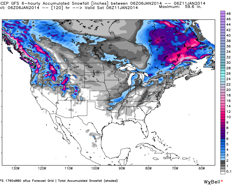
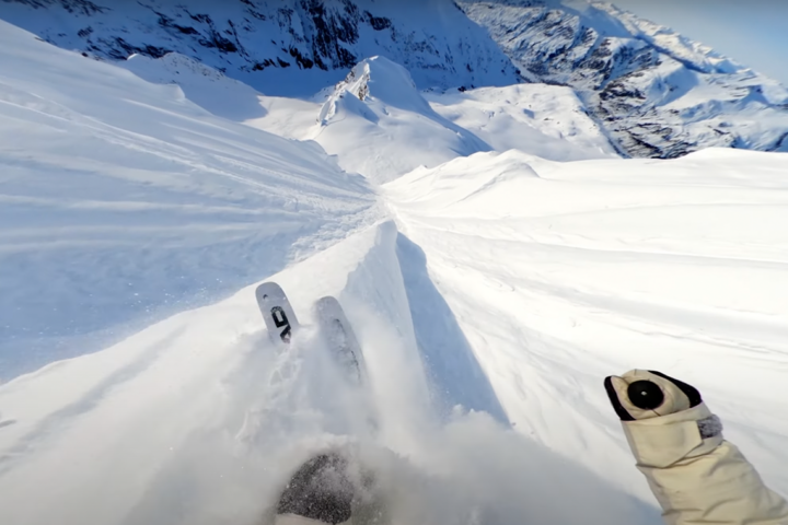
Heavy snow will hit the PNW and Rockies in the second half of the week. Image courtesy of OpenSnow.com.
The Northern Rockies
Montana, Idaho, and Wyoming are all going to receive a fresh refill of snowfall as the week moves on. The snow moves into Wyoming on Tuesday night, and for Jackson Hole, it won’t cease until Saturday night. A possible 1 to 2 inches could fall Tuesday night, up to 6 inches throughout the day and night on Wednesday, 3 to 8 on Thursday, and then a bit of a lull will occur on Friday before another 4 to 10 could drop on Saturday. The forecast is similar for Grand Targhee.
The folks in Idaho will be pleased with this week’s snow forecast, as almost every ski are in the state is projected to get nuked with snow. The best chances for season-making powder days will come at Brundage, Soldier Mountain, and Tamarack. Brundage could see 3 to 7 inches Wednesday night, 3 to 8 throughout Thursday, 1 to 9 on Friday, and then 7 to 16 inches on Saturday. Soldier Mountain stands to receive light to moderate snow from Wednesday through Friday, but could then see 9 to 15 inches throughout Saturday, and Tamarack could see 8 to 16 inches that day as well.
Like its two northern Rocky Mountain neighbors, Montana stands to see snow throughout the week. Some of the best snow will come during the middle of the week at ski areas like Montana Snowbowl (up to 14 inches from Wednesday through Thursday night), Turner Mountain (up to 13 inches from Tuesday night through Thursday), and Whitefish (up to 12 inches from Tuesday night through Thursday).
Utah
Skiers across Utah should have a chance to ski some powder this week. Alta and Snowbird are both projected to receive up to 14 inches from Tuesday night through Thursday night. The Canyons, Park City Mountain Resort, and Deer Valley should see some snowfall, with the Canyons expected to receive the most at up to 11 inches from Tuesday through Thursday night. Big Cottonwood Canyon neighbors Solitude and Brighton could see about a foot of new snow in that same time frame as well.
Stay up to date on weather in the Beehive State thanks to Evan Thayer.
Colorado
Light snow should fall across the northern portion of the Centennial state starting Tuesday night and lasting through Wednesday with a couple of inches of accumulation projected. More snow will fall starting on Thursday night and last through Friday afternoon, with Steamboat, Vail, Winter Park, and other Front Range resorts looking at 3 to 6 inches. According to Joel Gratz in his Colorado Daily Snow, “The southern San Juan mountains might get back into the action with the southern part of the splitting storm providing a spark to bring much-needed snow back to this area,” with Wolf Creek projected to see up to 8 inches in that time. The next chance for snow will come Saturday night and last into Monday, bringing anywhere from 4 to 8 inches of new snow.
For daily Colorado powder forecasts from OpenSnow founder Joel Gratz, click here.

The weather model through January 10. Image courtesy of OpenSnow.com.
The Sierra Nevada
Unfortunately, California’s dry winter looks to continue throughout the beginning and middle of this week. A couple of Tahoe resorts could see a flurry on Wednesday night, but with little to no accumulation. A better chance for accumulation will come starting on Saturday, as Alpine Meadows, Squaw Valley, Sugar Bowl, Sierra-at-Tahoe, and Kirkwood could all see up to 6 inches through Saturday night.
Bryan Allegretto provides daily snow forecasts for California, here.
The Northeast
The northeast will receive a visit from the Polar Vortex that has been dropping record low temperatures in the midwest, but fortunately for the east coasters, highs throughout the days will top out around 10 degrees. In terms of snow, it looks like northern resorts like Jay Peak, Stowe, and Sugarloaf will see some snow showers into Wednesday, but they won’t add up to much. Keep dancing to the snow gods, as OpenSnow meteorologist Brian Clark is projecting that the dreaded January thaw will rear its ugly head this weekend.
Brian Clark heads the New England snow forecasts with New England Daily Snow.
The Midwest
The bitter cold temperatures are still lingering in the midwest, but should move out in the next few days. In the coming days, it looks like the Upper Peninsula of Michigan is the only midwestern area to get any snow. Mont Ripley and Mount Bohemia stand to get a few inches from Tuesday night into Thursday, while Marquette Mountain could get 2 to 4 on Friday night.
For more from the Midwest, follow OpenSnow’s Andrew Murray.

Comments are closed.