Josh Bibby’s text message read, “I’m bringing my new throwing axe, three throwing knives, two hatchets, my fishing gear and a few fireworks. We can pick up more—there are lots of stores that sell fireworks on the way.” I replied with my list of fishing gear, shotguns, ammunition and various shooting targets. It seemed we were well equipped for the upcoming two-week-long adventure.
Leaving behind the zoo that is Whistler, BC’s, springtime pro ski and snowboard filming scene, we pointed ’er north towards quieter towns and bumpy logging roads. Our goal: use the rivers that run between Smithers, Terrace and Stewart, BC, as well as Hyder, AK, as our road map into the mountains. Bound for an area that is world renowned for both its backcountry skiing and its freshwater fishing, we had high hopes from peak to creek.
Given our agenda included exploring, skiing and fishing, we couldn’t have had a better crew. Despite Bibby, TJ Schiller and I having been longtime friends, we rarely end up on ski trips together. This outing was nearly 10 years in the making, and we were determined to make it one to remember. So, with enough weaponry and explosives to fend off a small army, and sleds loaded on the Armada- branded one-ton F-350 as well as Schiller’s truck and trailer, we were off to the Skeena River Valley with plans to grab photographer Bryn Hughes and cinematographer Jamie Tanner along the way.
We’d heard nothing but amazing things about the mountains that surround the towns of Terrace, Stewart and Hyder. As we made our way towards the northern coast, the mountains grew larger and more dramatic in profile—this was big country.
The peaks measure approximately 6,000 feet from summit to valley floor, where they collide with famed sport-fishing rivers such as the Skeena, Kalum, Bulkley and Kitimat. In these quaint, northern locales, a combination of AStar helicopters and high-powered riverboats are the preferred travel methods of outdoor enthusiasts. In order for us to reach the best spots—both in the mountains and on the rivers—it quickly became apparent that some impressive recreational tools would be required. With limited knowledge of the area, we turned to the Backroad Mapbooks, Google Earth and a few locals in order to scope potential access roads.
Our first stop on the journey was the Skeena Cat Skiing lodge in New Hazelton, 133 kilometers (82 miles) northeast of Terrace, perched on the Bulkley River. As we pulled up to the lodge, we encountered a cat skiing group; they were still in ski boots and enjoying some beers around a couple of bush-run Chevy Silverados while they reminisced about the day. We instantly felt at home. The family-run outfit was full of character and void of unnecessary luxuries that are often part of larger or more corporate cat skiing ops.
[juicebox gallery_id=”182″]
The next day, we followed owner and longtime guide, Jevon Zyp, on the 30-minute drive to the trailhead. Knowing the road like the back of his hand, he navigated with ease. The going was a bit tougher for our truck, thanks to the sled deck and double trailer in tow. The same could be said for Schiller’s truck, as it suffered from broken four-wheel drive. We narrowly avoided sliding off the road on a downhill, icy, off-camber corner before we arrived—adrenaline on high. Playing it off as ‘no big deal,’ my white knuckles moved from the steering wheel to handle bars, and we made our way into the hills.
“Bound for an area that is world renowned for both its backcountry skiing and its freshwater fishing, we had high hopes from peak to creek.”
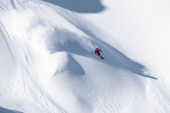
After a couple of hectic days on the road, nothing felt better than some powder hounding. Inclement weather left the alpine out of reach for the day, but deep snow in the trees provided an ideal alternative. We had fast laps and plenty of them. Our snow-filled beards and unwavering smiles made me think of the cat skiing group from the day prior. I now knew what they had been reminiscing about.
Next, we followed the Skeena River west into Terrace, checked in at the Bear Country Inn and mapped out our upcoming week. After bullshitting with some of the locals at a sled shop and cross referencing with Google Earth, we followed the Kitimat River south to a promising sled zone. At the end of a very muddy, active logging road, we encountered what seemed like a scene out of a horror film—a parking lot full of old abandoned logging equipment, most of which was in disrepair and several burned and/or collapsed mobile homes. We all started to think we might be killed and buried out there.
While discussing the eerie atmosphere, we mounted our sleds and made our way up the remainder of the snow-packed road. We could see our targeted terrain close by but had to figure out how to work our way above the tree line and into the alpine. Eventually, we came across an old set of sled tracks leading into the forest. We followed and soon after encountered flagging tape. We were headed in the right direction. After breaking trail (a solid group effort), we emerged into the high alpine to find a vast expanse, all to ourselves.
Snow stability was an issue in the area. A season’s worth of storms yielded several deep instabilities, and we were wary of the potential for large, destructive avalanches. We’d been in contact with local heli operators, compiling information about the terrain and snowpack. It was important that we gathered as much information from the locals as possible. It can be difficult and downright dangerous to go into an unfamiliar zone without in- depth knowledge of how snowfall and temperatures have interacted over the course of a season. For this reason, we were being particularly careful.
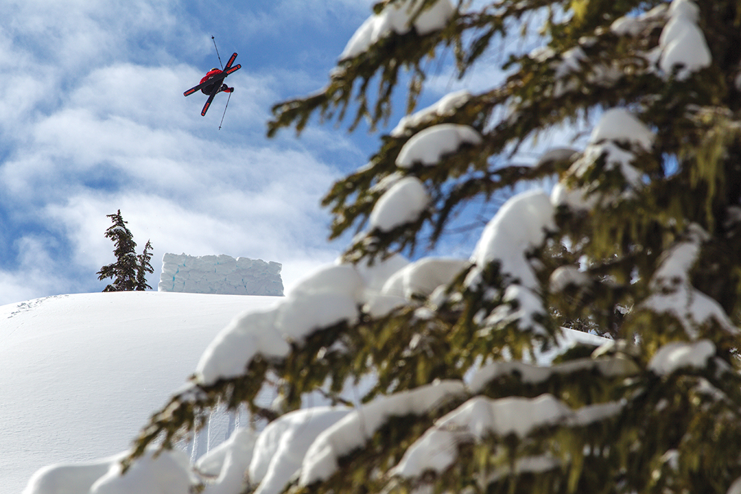
We used the info we’d gathered to find a prime spot to build a couple of jumps. The takeoff zone was a large island with ample room for two kickers, each with a separate landing zone. Stoke was high as Bibby, Schiller and I discussed what tricks we had planned. As we waited for the snow on the jump to set, excitement about the upcoming session mounted. It’d been years since we’d hit a backcountry jump together, and we were starting with the biggest jump so far this season.
Unfortunately, things didn’t play out well at first. The landing had a tricky double rollover, and on our first few jump attempts, we all over-rotated and slammed hard. Soon enough though, we were getting the hang of things. Bibby continued to stomp, becoming more confident with each landing. He capped off his session with an amazingly large, clean cork 7 blunt. Bibby’s display pumped some energy into the group. Schiller mustered the balls to hit the jump switch, and after navigating the rolling, off-camber inrun at impressive speed, he managed a nice switch 5 with the effortless style he’s known for.
I continued to pummel myself into the ground. In hindsight, I should have called it quits, but I continued to hit the jump out of sheer anger. After suffering a few of the harder bails I’ve had in recent memory, I walked away with a successful 720 under my belt. We went home stoked and sore. We knew that we’d have to head out again the next day or run the risk of seizing up on account of all that body slamming. This was not an option given we had another week ahead of us.
We continued north from the Skeena River Valley along the Bear River to Stewart and Hyder. The Stewart-Cassiar Highway has the highest concentration of avalanche paths in North America and is constantly buried by massive slides. Fortunately, we didn’t encounter any.

One thought on “Hook, Line & Send ‘Er: Navigating the rivers of British Columbia in search of pow”
Comments are closed.